
I was in my road warrior mode again, visiting my beautiful Morbihan , I decided to come visit this lovely town of Larmor-Baden to tell you about a wonderful monument, So glad found me pictures in my cd rom vaults that should be in my blog for you and me, The coastal town of Larmor-Baden is in my beautiful Morbihan and lovely region of Bretagne and in my belle France, Therefore, let me tell you about the Cairn de Gavrinis in Larmor-Baden !!! Hope you enjoy the post as I
The cairn de Gavrinis is a megalithic monument located on the island of Gavrinis in the town of Larmor-Baden in my beautiful Morbihan department no 56, in my lovely region of Bretagne of my belle France. It is close to the towns of Arzon and Locmariaquer (see post), very near the coast, as it only takes a few minutes by boat to reach it. Guided tours of the cairn are available by taking a boat from the Pen Lannic dock in the towns of Larmor-Baden or from Port-Navalo (see posts).
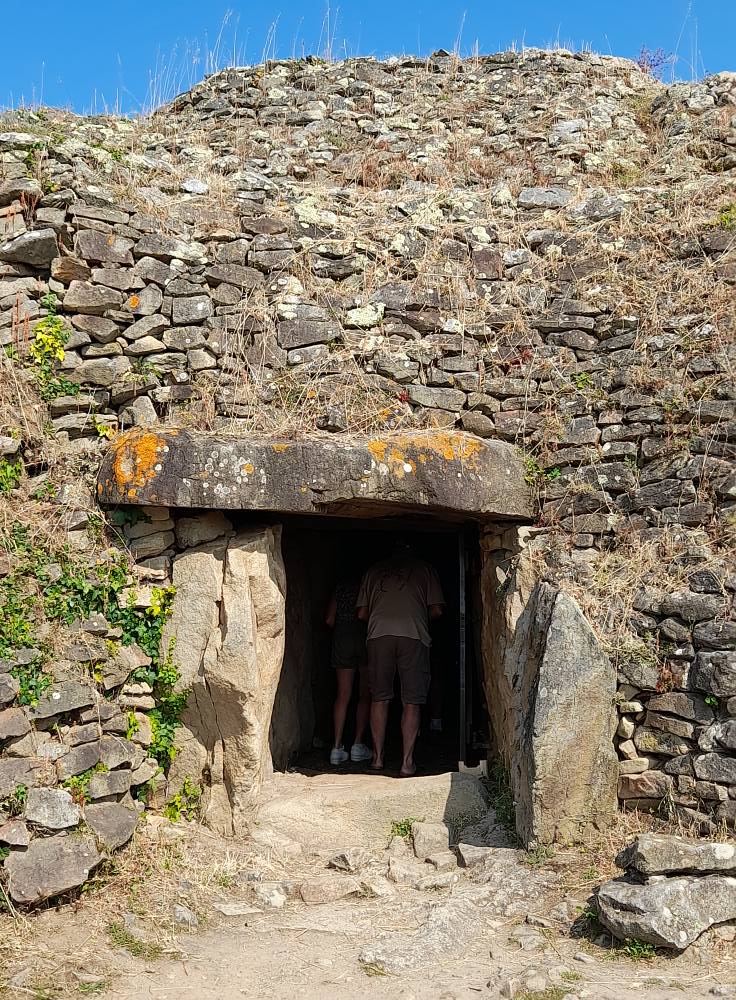
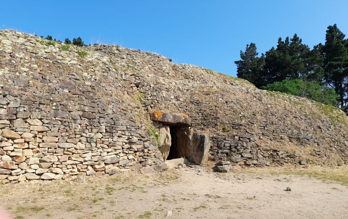
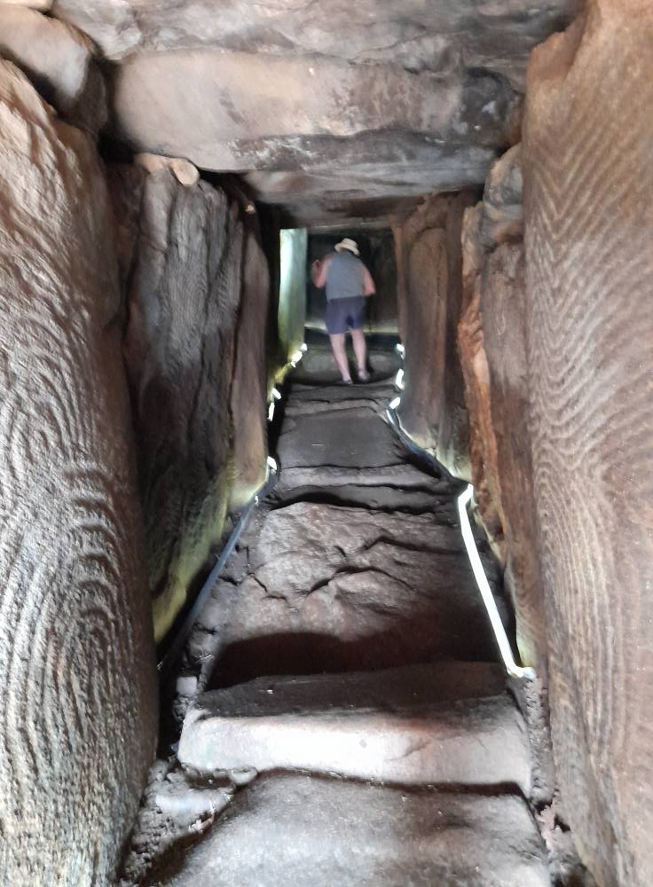
The cairn of Gavrinis features exceptional decoration; it is the most sumptuously decorated megalithic monument in all of Brittany and one of the most spectacular in Europe. The monument is a long-corridor dolmen with a single chamber. The cairn is almost circular (diameter of 54 to 60 meters) with a height of 6 to 8 meters; in fact, it is a quadrilateral with rounded corners. It is surrounded by carefully constructed facing walls, which contrast with the interior of the cairn, formed by an accumulation of stones of varying sizes. The internal mass of the cairn contains several concentric walls to contain the outward pressure. The upper part has areas disturbed by stone extractions, either ancient or medieval. The cairn represents a volume of 5,000 m³, corresponding to the stonework of a surface equivalent to three or four times that of the island. The interior corridor leading to the chamber is more than 13 meters long, making it the second longest corridor dolmen in Brittany after that of Mané-Rutual.(see post), Its width of 0.8 meter and its height of approximately 1.5 meters remain fairly constant from end to end, except for a slight narrowing in the middle. Its walls are composed of twenty-nine orthostats, most of which are made of light, fine-grained granite of local origin: fifteen (including two of quartz) on the northeast side and fourteen on the southwest side. The corridor is covered by nine capstones.
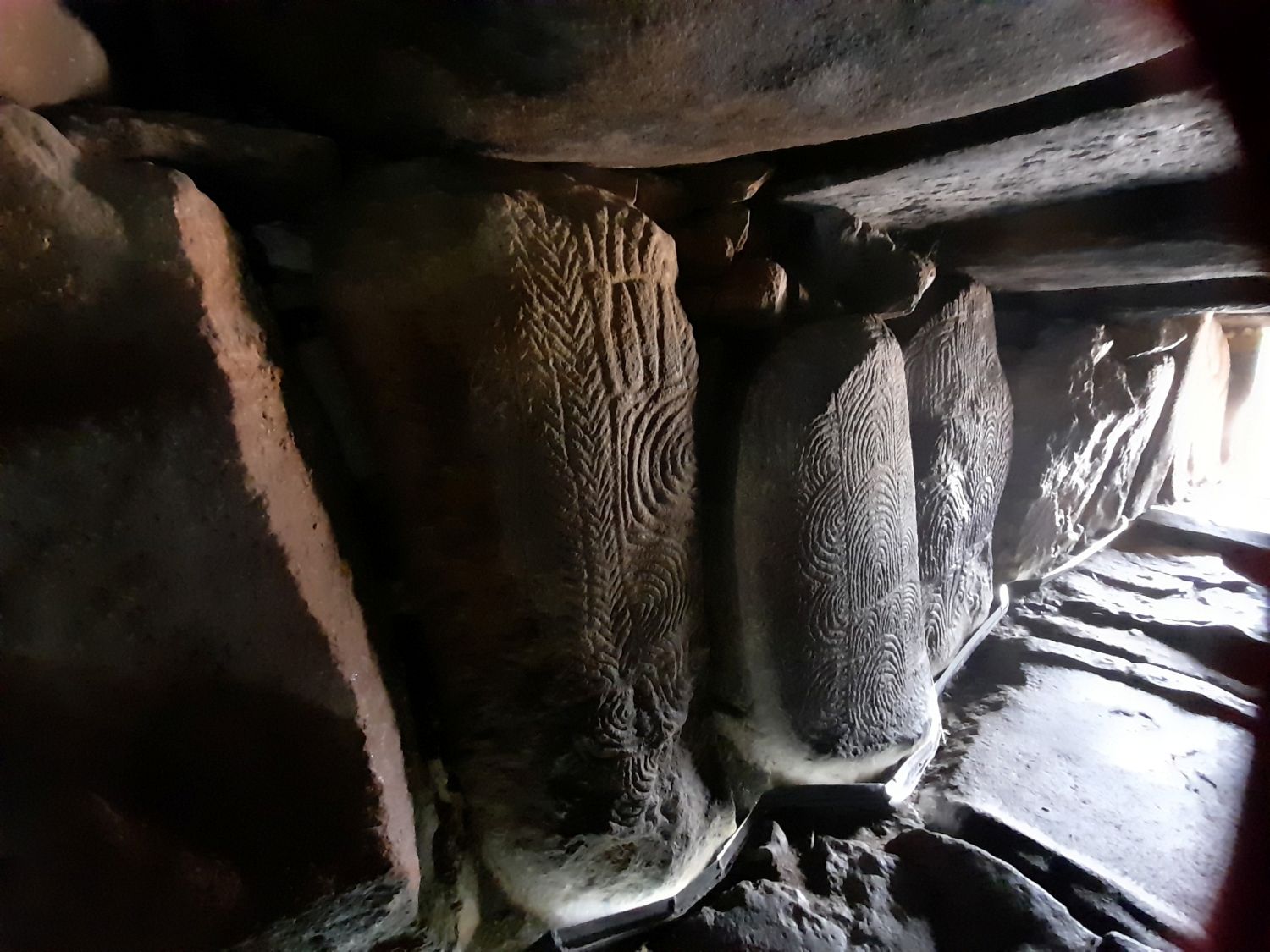
The burial chamber is trapezoidal in shape of 2.55 meters long, 2.45 meters wide at the back but only 2.10 meters at the entrance, and reaches an average height of 1.70 meters. The size of the chamber is almost insignificant compared to the mass of the cairn and the length of the access corridor, which raises the question of its function. It is located roughly in the center of the cairn. It is delimited by six orthostats. It is covered by a single capstone made of orthogneiss weighing nearly 17 tons. The overall quality of the construction is exceptional. Twenty-three of the twenty-nine orthostats are decorated, most often over their entire surface, with a decoration composed of engravings and pecked and incised motifs. The whole represents a composition of nearly 50 m². The slabs are decorated with various motifs (shields composed of interlocking arches, croziers, axes, zigzags and meanders, cupules, spirals) consistent with those visible in tombs and on menhirs of the region during the 5th millennium BC and 4th millennium BC. At the time the cairn was built , between 4250 and 4000 BC, the island was still connected to the mainland. Its use ceased around 3300-3100 BC. The light wooden structures that stood in front of the facade were burned and immediately covered with a mass of stone that sealed the entrance. A layer of sand was even added to transform this monumental cairn into a featureless mound. In the Middle Ages, the island was occupied by a monastery. In 1801, the site was purchased by Dr. Cauzique, then mayor of Crach (see post). In 1829, he began clearing the land to settle farmers there, razed the last remains of the monastery, and at the same time uncovered the cairn. It was thus that in 1832 he accidentally discovered, at the bottom of the crater, a crevice leading to the dolmen chamber, which appears to have already been visited. The first known excavations date from 1835. Further excavations were carried out by Gustave de Closmadeuc (a French surgeon and archaeologist) between 1881 and 1884 and Zacharie Le Rouzic (a French archaeologist and prehistorian) from 1925 to 1927. Le Rouzic carried out the first restoration work on the site around 1930. Between 1985 and 1995, Charles-Tanguy Le Roux (a retired general curator of heritage for Brittany and a renowned prehistorian) completely excavated the cairn and contributed to its development in the 1980s.
The town of Larmor-Baden on the Gavrinis island and cairn :https://www.larmorbaden.com/tourisme/sites-a-visiter/ile-de-gavrinis
The official Cairn de Gavrinis : https://cairndegavrinis.com/
The local Bay of Quiberon tourist office on the Cairn de Gavrinis : https://www.golfedumorbihan.co.uk/fiche/cairn-de-gavrinis-en/
The Morbihan dept 56 tourist office on the Cairn de Gavrinis : https://morbihan.com/decouvrir/le-morbihan-et-ses-perles-bretonnes/destination-golfe-du-morbihan/ile-de-gavrinis/
The Bretagne region tourist office on the Cairn de Gavrinis : https://www.brittanytourism.com/destinations/the-10-destinations/southern-brittany-morbihan-gulf/gavrinis/
There you go folks, a wonderful coastal pretty town of Larmor-Baden, worth the detour me think, The wonders of my beautiuful Morbihan. A visit to the Cairn de Gavrinis is a must, me think. Again, hope you enjoy this post on the Cairn de Gavrinis in Larmor-Baden !!! as I.
And remember, happy travels , good health,and many cheers to all !!!
