
We have driven and walked in my eternal Paris, and would like to have an imprint in my blog on the wonderful family times we had there, There is so much to see , doing my best, and glad found me these pictures in my cd rom vault ,which now transposing in my blog for you and me, This was my former worked city, so glad to post more memorable spots on it,like the metro stations below, I thank you for your readership over the years and to bear with my rants! After Paris is to rant, shout and yelled about, me think. Therefore, here is my take on curiosities of Paris, part XLIX !!! Hope you enjoy the post as I.
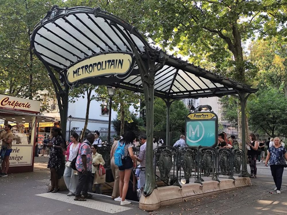
The metro Abbesses is a station on line 12 , located in the 18éme arrondissement of Paris.On this section, the tunnel develops under the buildings of the Butte Montmartre or mound with a strong ramp of 4%. Due to the elevation on the surface, the quays of the station are located 36 meters below the surface, which makes it the deepest station of the Paris metro, The station was opened on January 30, 1913, almost three months after the Inauguration of the second extension of line A of the Nord Sud railroad company, from the provisional terminus of Pigalle to Jules Joffrin. On the RATP level of line 12, the station carries as a subtitle Butte Montmartre by the name of the mound under which it is located. This subtitle is however absent from the quays of the station, inscriptions on “nord-sud” style earthenware lending themselves badly. ,On March 27, 1931, line A became the current metro line 12 following the absorption of the Société du Nord-Sud on January 1, 1930 by its competitor, the CMP , which manages the concession of most of the other lines of the network ,The station has a single access entitled “Place des Abbesses”, leading to the central media of the aforementioned square, to the right of the street 2 Rue La Vieuville, having kept its original decorations on the cheesy walls. Consisting of a fixed staircase, it is decorated with a Guimard edict wearing a glass roof nicknamed “dragonfly”; This edict was originally present at the Hôtel de Ville station (access no 6, located on rue de Lobau), and reassembled to its current location in 1974 due to the creation of an underground car park adjoining the city hall of Paris. It served as a set of filming for the films “The fabulous destiny of Amélie Poulain” by Jean-Pierre Jeunet and the “Le Locataire” or tenant of Roman Polanski.
The official RATP local transport on metro line 12 : https://www.ratp.fr/en/plans-lignes/metro/12
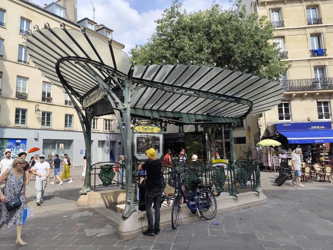
The metro Châtelet is on lines 1, 4, 7, 11 and 14, located straddling the 1ert and 4éme arrondissements of Paris. It is one of the two stations of the network to be served by five metro lines. It constitutes the nerve center of the Paris metro and is part of a more global exchange center incorporating the Châtelet – Les Halles RER station as well as the Les Halles metro station.It includes two parts linked together by a long corridor equipped with two treadmills. The latter serve under Place du Châtelet: line 7 under the Quai de Gesvres (between Pont-Neuf and Pont Marie); Line 11 under avenue Victoria ,further north, they serve: line 1 under rue de Rivoli (between Louvre – Rivoli and Hôtel de Ville) ; line 4 under rue des Halles (between the Halles and Cité); Line 14 diagonally between these two previous streets, in parallel to line 4 (between the Pyramid and Gare de Lyon stations). The station is connected, from the northern part, by another corridor comprising three rolling sidewalks, at the RER station of Châtelet – Les Halles ,which it serves lines A, B and D) and, through it, Les Halles Metro station 4. The strictly known Châtelet station is open on August 6, 1900, more than two weeks after the first section of line 1 between Porte de Vincennes and Porte Maillot. On April 21, 1908, the line 4 was open with the inauguration of its first section on the right bank of the Seine, of which it provisionally constituted the South terminus from Porte de Clignancourt until January 9, 1910, date of completion of the double under-flowial crossing, allowing the tracks to continue through the left bank of the river to Porte d’Orléans. On April 16, 1926, the Line 7 station was open with the commissioning of its extension from Palais Royal (now Palais Royal – Louvre Musée) to Pont Marie. On December 9, 1977, the station was corresponded to the new Châtelet- Les Halles on lines A and B of the RER (joints by line D on September 27, 1987), itself connected to the station Les Halles of Line 4 which, in parallel, is rebuilt in the east of its initial location (located under Rue Baltard) in order to allow rapid pedestrian relations with the RER quays. Finally, on October 15, 1998, the Line 14 station was opened in turn on the occasion of the inauguration of its first section between Madeleine and Bibliothéque François-Mitterrand (library). The station draws its main name from its proximity to the Place du Châtelet, which is set up on the site of the Grand Châtelet, a former fortress which served as prison and court under the old regime, before being demolished in 1802.
The official RATP local transport on metro Châtelet : https://www.ratp.fr/vos-lignes/vos-stations/chatelet
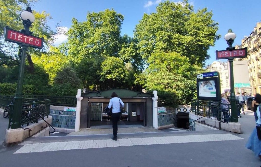
The metro Sèvres – Babylone is a station on lines 10 and 12 , located on the border of the 6éme and 7éme arrondissements of Paris. The station is located at the intersection between Boulevard Raspail, Rue de Sèvres and Rue de Babylone, The platforms being established on line 10 (between Vaneau and Mabillon stations, separated from the latter by the ghost station Croix-Rouge), under Rue de Sèvres at the intersection, on the edge of Square Boucicaut between Rue Velpeau and Boulevard Raspail; on line 12 (between Rue du Bac and Rennes), approximately oriented under Boulevard Raspail, between Rue de Sèvres and Rue de la Chaise. The station has three entrances: Access no. 1 “rue de Sèvres”: a fixed staircase decorated with a Dervaux candelabra, opening onto 18, rue de Sèvres; Access no. 2 “rue Velpeau – Le Bon Marché”: entrance adjacent to Boucicaut Square, at the corner of rue de Sèvres and rue Velpeau, consisting of a short fixed staircase diverging into two staircases, each decorated with a Dervaux mast and an escalator rising in the center; and access no. 3 “boulevard Raspail on the pairs side of Boucicaut Square: exit adjacent to the entrance to Boucicaut Square, consisting of a fixed staircase coupled with an escalator rising from the platform of line 12 towards Mairie d’Issy. The platforms of both lines are of standard configuration: two per stopping point, they are separated by the metro tracks located in the center and the vault is elliptical. The station opened on November 5, 1910 with the commissioning of the first section of line A of the Nord-Sud Company, between Porte de Versailles and Notre-Dame-de-Lorette. It owes its initial name of Sèvres – Croix-Rouge to its proximity to the rue de Sèvres, an old road which led from Paris to Sèvres in the 13C, but also to the crossroads called “carrefour de la Croix-Rouge” in the 18C located at the beginning of the rue du Cherche-Midi. In order to avoid any confusion with the latter, the stations of the two lines have been called Sèvres – Babylone since then, thus emphasizing their proximity to the rue de Babylone, another old road which disappears into the Grenelle plain and which owes its name since 1673 to the bishop of Babylon, Jean Duval, known as Monsieur de Babylone, then Bernard de Sainte Thérèse.
The official RATP local transport on metro line 12 : https://www.ratp.fr/en/plans-lignes/metro/12
The metro Pigalle is a station on lines 2 and 12 , located on the border of the 9éme and 18éme arrondissements of Paris. The station is located under Place Pigalle, itself built at the foot of the Butte Montmartre, on the administrative border between the Saint-Georges quartier ,the Grandes-Carrières quartier and the Clignancourt quartier or neighborhoods. The platforms are located on line 2,on the forementioned square and oriented along the axis of Boulevard de Clichy; on line 12, in a sharp curve under the square and oriented along the axes of Rue Frochot on the one hand and Rue André-Antoine on the other; its stopping point is thus located under the tunnel of line 2, which is crossed perpendicularly, and under a sewer collector. The station of line 2 is inserted between the stations Blanche and Anvers, while that of line 12, buried deeper in the ground and established on a level, is framed by the stations Abbesses and Saint-Georges, the first being geographically quite close.
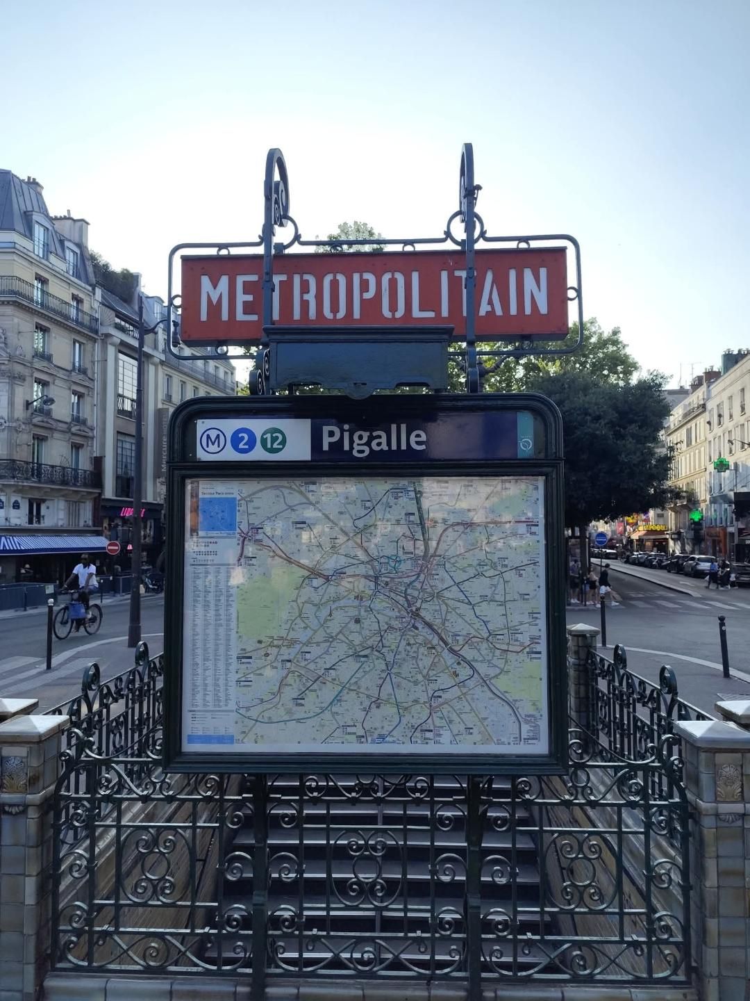
The station opened on October 7, 1902 with the commissioning of the section between Étoile (current Charles de Gaulle – Étoile station) and Antwerp of line 2 North of the company known as CMP, which became more simply line 2 on October 17, 1907 following the absorption of line 2 South (section of the current line 6) by line 5 on the previous October 14. On March 27, 1931, line A became the current metro line 12 following the absorption of the Nord-Sud company on January 1, 1930 by its competitor, the CMP, which operated most of the other lines. The station owes its name to its location beneath Place Pigalle, in the heart of the Pigalle quartier or neighborhood, to which it gives its name, as well as to its proximity to Rue Jean-Baptiste-Pigalle (formerly Rue Pigalle), where the eponymous sculptor lived from 1714 to 1785. The station has three metro entrances, all under the name “Place Pigalle,” each consisting of fixed staircases leading to the central reservation of Boulevard de Clichy. The main entrance, located on Promenade Coccinelle, provides direct access to the platforms of Line 2 only. It is adorned with a Guimard entrance, designed in 1900 by the architect Hector Guimard. The other two access hoppers are located more in the center of the square, on the central reservation at the level of nos, 20 and 22 of the boulevard, one is only accessible in the direction of the exit. They are decorated with balustrades in the characteristic style of the former Nord-Sud company, in wrought iron punctuated by ceramic pillars. The station has two separate reception halls: the first, giving direct access to line 2, is connected to the eastern entrance of the station, while the second, closer to line 12, is accessible from the western hoppers. The platforms of the two lines, with a conventional length of 75 meters, are of standard configuration for the Paris Metro: two per stopping point, they are separated by the metro tracks located in the center and the vault is elliptical. The station on line 2 is decorated in the blue “Ouï-dire” style. The station on line 12 is set in a pronounced curve and its vault is semi-elliptical. The decoration is in the “Andreu-Motte” style with two orange light ramps, benches treated in flat brown tiles and orange “Motte” seats arranged on the latter.
The official RATP local transport on metro line 2 : https://www.ratp.fr/plans-lignes/metro/2
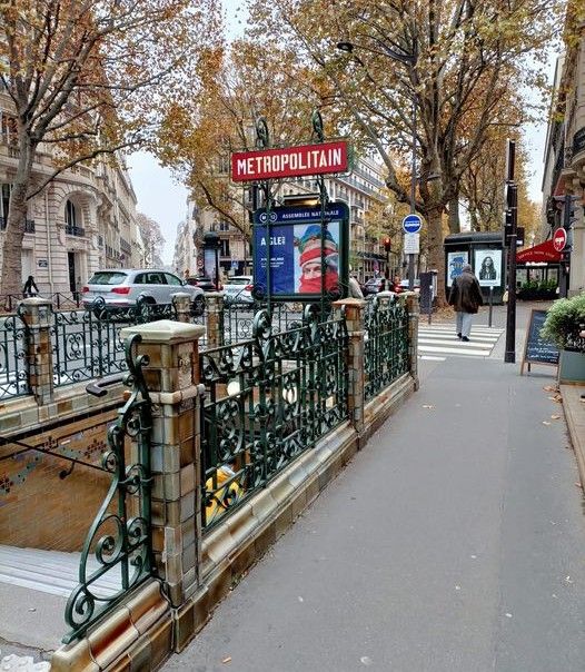
The metro Assemblée Nationale is a station on line 12, located in the 7éme arrondissement of Paris. The station is located between Concorde and Solférino métro stations. It is located under Boulevard Saint-Germain between Rue de Lille and Rue de l’Université. The station opened on November 5, 1910, under the name Chambre des députés. It was called this until June 30, 1989. It received its current name, more in line with the official name of the first chamber of the French Parliament under the Fifth Republic. The station has 3 entrances: Access no. 1 “Boulevard Saint-Germain”: a staircase at No 239, Boulevard Saint-Germain; Access no. 2 “Rue de Lille”: a staircase at 278, Boulevard Saint-Germain and Access no. 3 “Rue de l’Université”: a staircase at 233, Boulevard Saint-Germain. The wrought iron surrounds of the entrances are characteristic of the Nord-Sud Company’s style. The metro Assemblée Nationale is a standard-configuration station with two 75-meter-long platforms separated by the metro tracks. The vault is semi-elliptical, characteristic of Nord-Sud stations. On each platform, five themes are presented through specific visuals and videos on screens inserted into the bodywork: on the platform toward Mairie d’Issy : République, Lois, Députés, Séance publique and Débats Finally, video screens present the public session in progress.
The official RATP local transport on metro line 12 : https://www.ratp.fr/en/plans-lignes/metro/12
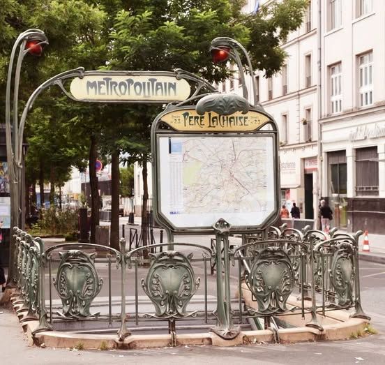
The metro Père-Lachaise is a station on lines 2 and 3 , located on the border of the 11éme and 20éme arrondissements of Paris. The station is located on the administrative border between the quartiers or neighborhoods Saint-Ambroise, Roquette, and Père-Lachaise . It is located at the intersection of Boulevard de Ménilmontant, Avenue de la République and Avenue Gambetta, west of Place Auguste-Métivier, the platforms being established: on line 2, south of the intersection, along the axis of Boulevard de Ménilmontant (between the metro stations Ménilmontant and Philippe Auguste); on line 3, and of the crossroads under the end of Avenue de la République, along axis (between the metro stations Rue Saint-Maur and Gambetta, the latter being preceded by the former Martin Nadaud station which is incorporated into it). A single-track service connection branches off at the tip of the line 3 track towards Gallieni, upstream of the station, then runs alongside the stopping points of both lines to connect at the tail end to the line 2 track towards Nation, downstream of the station. The station opened on February 25, 1903, more than three weeks after the opening to the public of the section between Antwerp and Bagnolet (now Alexandre Dumas) of Line 2 Nord, which took place on January 31. It owes its name to its location of the Père-Lachaise cemetery, the largest Parisian cemetery within the city walls, which owes its international reputation to its celebrity graves, making it a major tourist attraction in Paris and the most visited cemetery in the world. On October 19, 1904, the Line 3 station opened of its first section from Avenue de Villiers (now Villiers) until January 25, 1905, when the line was extended for the first time to Gambetta. On October 17, 1907, Line 2 Nord became simply the current Line 2 following the absorption of Line 2 Sud (section of the current Line 6) by Line 5 on October 14. On February 25, 1909, given the greater depth of the platforms on line 2 compared to those on line 3, the station was the first in the network to benefit from an escalator. The station has two accesses divided into three metro entrances: access no. 1 “Boulevard de Ménilmontant” comprising a main entrance and a secondary exit established back-to-back, the first consisting of a fixed staircase, the second having an ascending escalator, both opening at the end of allée Nicole-Girard-Mangin on the central reservation of boulevard de Ménilmontant, south of the intersection with avenues de la République and Gambetta; access no. 2 “Avenue de la République”, consisting of a fixed staircase, located at No. 103 of the aforementioned avenue; This secondary entrance provides direct access to the platforms of line 3 only. Two Guimard entrances adorn the main hopper of access no. 1 and no. 2 respectively, the second having no portico. The secondary exit attached to access no. 1 is surrounded by a more sober balustrade, in green painted steel. The platforms of both lines, with a conventional length of 75 meters, are of standard configuration for the Paris Metro: two per stopping point, they are separated by the metro tracks located in the center. Their decoration is in the “Andreu-Motte” style in both cases.
The official RATP local transport on metro line 2: https://www.ratp.fr/plans-lignes/metro/2
The official RATP local transport on metro line 3: https://www.ratp.fr/en/plans-lignes/metro/3
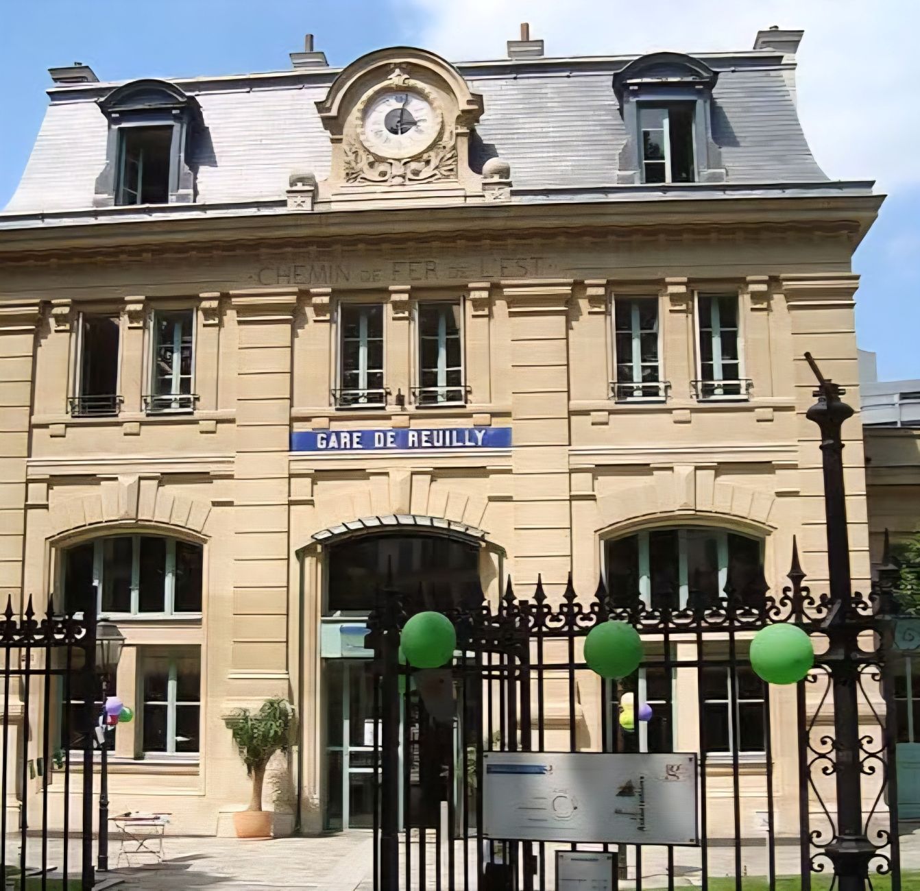
The former Gare de Reuilly train station was a railway station in operation from 1859 to 1985, located at 181, avenue Daumesnil in the 12éme arrondissement of Paris. The Paris-Bastille to Marles-en-Brie line opened on September 22, 1859. It was closed to passenger traffic in 1969, following its takeover by RER line A, which brought passengers to Nation station. In 1985, freight activity was still significant. However, in order to allow the Paris city hall to carry out a real estate transaction, the SNCF sold it the aprox 10 hectares of the station’s right-of-way, including the marshalling and freight yard. The city redeveloped this space by initiating the “ZAC de Reuilly” (commercial activity zone). After the cessation of railway activity, the old passenger building of the station was used as offices by the pilot organization for the reconversion of the district. After the completion of the project, the building, preserved as a railway symbol, was rehabilitated and converted into a house of associations of the 12éme arrondissement or district. This new use was inaugurated on December 13, 2003. The garden of the Gare de Reuilly was created in 1995, between the rear of the station and the Allée Vivaldi. This track corresponding to the old railway line transformed into Promenade Plantée.
The City of Paris on the garden of the Gare de Reuilly : https://www.paris.fr/lieux/jardin-de-la-gare-de-reuilly-2602
The Paris tourist office on the 12éme arrondissement de Paris : https://parisjetaime.com/eng/article/explore-paris-s-12th-arrondissement-a824
There you go folks, a dandy city to explore and enjoy with the family, Memorable moments in my eternal Paris, driving and walking all over in my road warrior trails brings out sublime awesome spots with nice memorable family visits of yesteryear always remember and always looking forward to be back, eventually. Again hope you enjoy the post on curiosities of Paris , part XLIX !!! as I.
And remember, happy travels, good health, and many cheers to all !!!
