
Well we like to think of rivers in France passing by city centers, come to mind the most famous Seine in Paris. However, there are litterally thousands little to medium to larger size towns here that have the same presence, except my town … However, one major river in Bretagne that passes by several towns is the Blavet. I was in Pontivy in my beautiful Morbihan 56, and lovely Bretagne, and would like to tell you a bit more about the Blavet river.
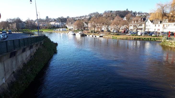
The Blavet is a coastal river which flows in the departments of Côtes-d’Armor (22) and Morbihan (56) and empties into the Atlantic Ocean near Lorient. The Blavet is called ar Blavezh in the Breton language. This is a wonderful area for sights and walks, we seems to do it each time in Pontivy. Of course, a great bicycle lanes to go along it as well.
The Blavet river is 148.9 km long . The course can be divided into several sections: the Haut Blavet upstream of Gouarec, the section of the Nantes to Brest Canal from Gouarec to Pontivy, the section of the Blavet Canal from Pontivy to Hennebont and the estuary downstream of Hennebont. Halfway through, at the Nantes to Brest canal, its course is suddenly interrupted by the Guerlédan dam which gives birth to the largest artificial lake in Bretagne, Guerlédan Lake.
The Blavet river rises in the Côtes-d’Armor, at the limit of the Monts de Haute-Cornouaille and Trégor, 5 km southwest of the town of Bourbriac, at an altitude of 280 meters. Its course then merges with that of the Nantes to Brest canal to Pontivy. This channel is regulated by a system of locks built in the post-Napoleonic period. From Pontivy, and up to Hennebont where maritime navigation begins, the Blavet is artificially navigable for 59.6 km under the name of the Blavet canal thanks to the presence of 28 locks which allow it to cross a difference in height of 54 meters.

The canalization of this river between Pontivy and Hennebont, planned in 1783, was not completed until 1825, following the decision taken by Napoleon I in 1806, to channel the Blavet to Lorient, and to connect it to a Nantes canal in Brest. Over a length of 60 km, the drop of 54 meters is bought by 23 locks. Floods can be very significant given the already large size of this river and its catchment area The maximum instantaneous flow recorded at Languidic during this period was 518 m3 / s on January 6, 2001, while the maximum daily value was 439 m3 / s on the same day.
The City of Pontivy on its water source heritage: https://ville-pontivy.bzh/decouvrir/histoire-patrimoine/pontivy-un-territoire/
The Canals of Brittany on the Blavet river : https://www.canauxdebretagne.org/canaux-de-bretagne_le-blavet.htm
The AF3V green ways of bicycling along the Blavet river : https://www.af3v.org/les-voies-vertes/voies/193-search_tag/
There you go folks, always pleasant to be here, on Napoleonville now Pontivy and even one of my sons worked here for a while for the memories’ sake, and of course we have visited the town several times, Hope you enjoy the post on the wonderful Blavet river as I
And remember, happy travel, good health, and many cheers to all !!!
