
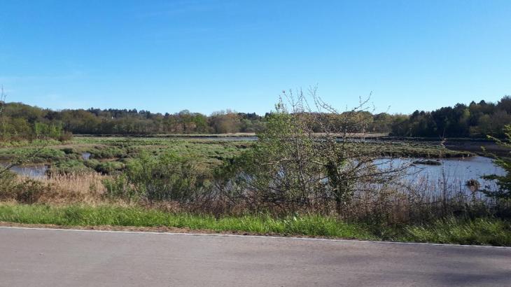
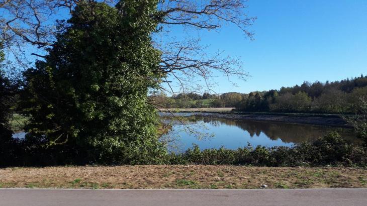
I was passing today by it (and past by almost every day! ) and always trying to get a picture hard when you have swampy areas and heavy traffic passing by on the road D768. Well today took some nice pictures me think to tell you about the real Loc’h River of Auray!! Hope you enjoy it as I.
The Loc’h river takes its source in Plaudren and goes west , then branches off to the south at half of its course. It becomes the Auray river (see post), a northern projection of the Gulf of Morbihan, in the town of Auray, just west of Pluneret (see post). The towns of which the Loc’h goes thru are Plaudren (source / origin), Locqueltas, Locmaria-Grand-Champ, Grand-Champ, Brandivy, Plumergat, Pluvigner, Brech, Pluneret, Auray its mouth. In Tréauray in the town of Brec ‘h, it widens and becomes like a lake, where fishermen like to fish for trout and pike. In terms of cantons, the Loc’h has its source in the canton of Grand-Champ, crosses the canton of Pluvigner and has its mouth in the canton of Auray. The Loc’h river, 45 km long crosses the department on the south to Auray to flow into the Gulf of Morbihan, by the port of Saint Goustan (Auray) it takes the name of the Auray river.
 In Auray, Tréauray is a green valley in the hollow of which flows the Loc’h river. The Loc’h river, has its source in the north of the department and crosses the country of Auray to come and throw itself into the Gulf of Morbihan. At the Port of Saint-Goustan, it takes the name of Rivière d’Auray (see post). The bridge of Tréauray, Tré-Auray perhaps comes from Trec’h (the passage in Breton) of Auray. A small granite bridge which spans the Loch river where its fresh waters flow into the waters of the Gulf of Morbihan, which under the influence of the tides that comes up here by meandering in the marshes of the wide valley of Tréauray.
The territory is traversed by the Loch river and the Reclus stream. Both are bordered by more than 30 ha of natural spaces, They are call
The La Petite Forêt or the small forest , extends over 16.4 ha of wooded area along the Loch River, on the edge of the territory and … a stone’s throw from the center of Auray. A double path clears the site along its entire length. It forms two loops. The site is also accessible from Rostevel near the railway line. Beech, chestnut and oak are among the main species. Also noteworthy are frail, birch and willow, broom and elderberry, foxgloves and hawthorn. Not to be missed: the flight of the Belon shelduck on the river… The Reclus valley, on either side of the Reclus stream, covers just over 20 ha. It borders several collective housing districts over two-thirds of its length to extend into the historic district of Kerléano where the Chouan chief (Gen) Georges Cadoudal was born, and also, buried in a memorial, (see post). The setting concerns land partly wooded and paved with paths, partly laid out as parks, including Parc Utting equipped with games for children.
The Bay of Quiberon tourist office on Auray : https://www.baiedequiberon.co.uk/auray
The Bay of Quiberon tourist office on Pluneret from where the pictures were taken: https://www.baiedequiberon.co.uk/pluneret
The Morbihan dept 56 tourist office on the little forest or petite forêt : https://www.morbihan.com/auray/la-petite-foret/tabid/12564/offreid/caad3d71-855d-4b36-9f36-d7169e4bf7a9
There you go folks, a nice natural environment always nice to see and to walk its borders more inland by Bréc’h and sea side by Auray. A wonderful site of my beautiful Morbihan on the Loc’h river. Hope you enjoy the nature post as I.
And remember, happy travels, good health, and many cheers to all!!!
