
Well as you know, and I have mentioned in previous posts; all great cities have a river! And yes nearby Quimperlé has a river ,call the Laïta! And we have been by it and is beautiful natural habitat right in the middle of the city. Therefore, let me give you my take on the Laita river of Quimperlé !! Hope you enjoy the post as I
The Laïta is a river estuary formed by the Ellé and the Isole river after their confluence. The name Laïta does not appear for the first time in official writings until 1825, on the cadastre of Quimperlé. In the writings dating from before the French revolution, the river which flows from Quimperlé to the sea still bears the name of Ellé. The origin of the name Laita remains obscure.

Its route partially serves as a natural border between the departments of Finistère (29) and Morbihan (56) . Its right bank is in particular partly occupied by the national forest of Carnoët for over 6 km. The entrance to the ria is made difficult to access because of a moving underwater sandbank and a pulley. Indeed, when the wind blows from the South or the West a bar forms making navigation dangerous. Laïta drains an area of 832 km2 at its point of departure in Quimperlé and 917 km2 at its mouth at the port of Pouldu or 922 km2 according to SANDRE (Le Service d’administration nationale des données et référentiels sur l’eau ) or the National Administration Service for Water Data and Repositories.
Laïta is responsible for frequent and serious flooding in the lower town of Quimperlé, Indeed I saw one that was back in 2013 pretty big one. For an overflow threshold of 3 meters, the floods of 1883, 1925, 1974, 1995 and December 24, 2013 reached 4.50 meters; the most important flood, in December 2000, was marked by a water height of 6 meters. The causes are multiple, the irregularity of the flows of the Ellé and especially of the Isole, the role of tides, the containment of rivers for 300 years, changes in the grove and upstream crops.

A bit of history associated with the Laïta river!
The banks of the Laïta were already frequented in prehistoric times, as evidenced by the presence of a tumulus in the forest of Carnoët. The more or less legendary Count Conomor, a true Breton Bluebeard, would have taken up residence there in the 6C. The remains of its castle, the Château de Carnoët, are still visible today. In the year 868, the Vikings went up the course of the river and destroyed the city of Quimperlé, called at the time Anaurot. Around 1170, monks from the Cistercian abbey of Langonnet, under the leadership of their abbot Maurice Duault, settled on the banks of the Laïta and founded a monastic establishment there, which would later take the name of Abbey Saint-Maurice de Carnoët.
During WWII, with the arrival of the American troops of General Patton in Brittany, the Nazis fell back on the region of Lorient to constitute a pocket of resistance there. Laïta then served as a western demarcation line for the Lorient pocket. The Nazis did not cross the estuary but did not hesitate to bombard the opposite bank, targeting the Abbey Saint-Maurice de Carnoët , the buildings of which were badly damaged.
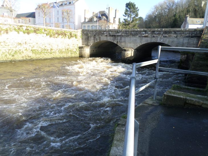
In Quimperlé, the Ellé and Isole joint to form the Laïta by the roads D765 (Quai Surcouf) and D783 (Quai Brizeux). You have great view points along these roads of beautiful natural habitat just in town! Take a side step to visit the Parc Le Bel-Air and the Prairie Saint Nicolas, and then see the river goes underneath the expressway N165 to thereafter start the borders of Finistére and Morbihan departments of Bretagne! Lovely indeed!
The Vigicrues webpage on tides and more tech info on the Laïta: https://www.vigicrues.gouv.fr/niv3-station.php?CdEntVigiCru=8&CdStationHydro=J490201002&GrdSerie=H&ZoomInitial=3
The local Quimperlé les rias tourist office on the Laïta: https://www.quimperle-lesrias.bzh/en/the-laita-valley/
The local Lorient South Brittany tourist board on the Laïta : https://www.lorientbretagnesudtourisme.fr/fr/immanquables/guidel/guidel-la-laita-et-ses-rives/
There you go folks, I told you I like nature too, the wild one and with a body of water, sea or river even better, just wonderful for the soul to be here and stroll/walk/jog along this wonderful river. Again, hope you enjoy the post on the Laita river of Quimperlé !! as I
And remember, happy travels, good health, and many cheers to all !!!
