
I like it and need to tell you all about it with a mixture of old and new pictures. The Presqu’île de Gâvres is a peninsula just south of me and as it was looking for new places to see in my beautiful Morbihan saw it on a google map!! So decided to take a look and it was marvelous we love it. Therefore, here is my new take on the Presqu’île de Gavres, part IV !!! Hope you enjoy the post as I.
The Gâvres is a peninsula opposite Port-Louis, at the entrance to the Lorient Harbor and east of the island of Groix. Originally, the rocky end was an island that was joined to the mainland by a tombolo (Dune cordon). This is parallel to the mainland and forms at high tide the small sea of Gâvres, a lagoon extending over 350 hectares, traditional fishing area on foot of clams and shells. This body of water is ideal for windsurfing or kitesurfing and amateur boat fishing. The cordon dunes is the largest in Bretagne and stretches from Pointe de Gâvres to the fort of Penthièvre, in the town of Saint-Pierre-Quiberon along the côte sauvage (see posts) or wild coast south of me. In Breton, the name of the town is Gavr. the toponym comes from the Breton gavr which means goat. The island would be the Goat Island or the tip of the goat.
Fort de Porh-Puns, a first fortification, a simple battery is built on the site in 1695 on the initiative of the Marquis of Lavardin. Equipped with 10 cannons and 2 mortars. this strategic location is chosen to protect the citadel of Port Louis and the Bay of Lorient a fort replaces the original battery in the course of the 18C with a corps of guard, capable of accommodating 60 soldiers there In 1846. The Fort enjoys a restoration campaign in the 1870’s, and later the fort is disarmed after WWII. You can walk around it but cannot go in.

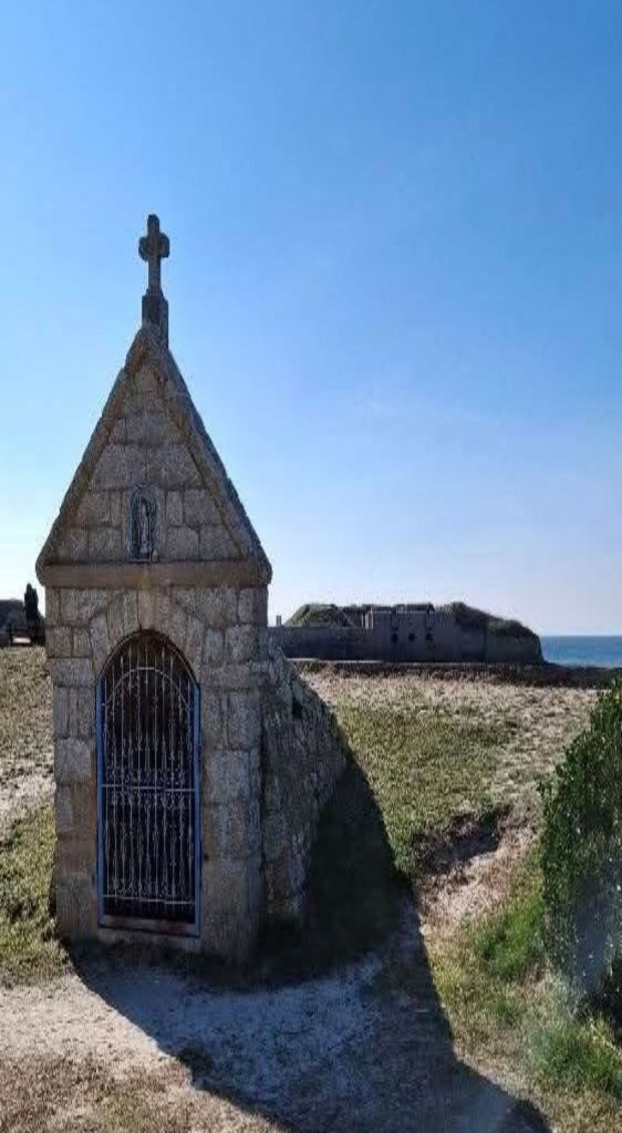
Fountain of St Gildas. There was a well dating from the 11C. The fishermen (the first port of Gâvres was in this cove) and also the inhabitants came to draw water from it. At the time of the company of India, the ships were moored in the bay, and sailors were coming in canoe to get supply of water. .In the 17C, the well was covered with stone and became the Fountain Saint-Gildas, with 17 steps.down. In a small niche there is a statuette of Saint Gildas. The well has been clogged, only a few steps can be seen but the vaulted architecture is very well visible..Very near the Fort de Porh Puns.
Numerous bunkers dating from WWII are still present, with armoured doors, cannon, mortar and machine gun locations. These blockhouses kept the entrance to the Bay of Lorient, which was during WWII an important base for the submarines of the Kriegsmarine (nazi navy).

The Morbihan dept 56 tourist office on porh puns beach fort bunkers : https://morbihan.com/a-voir-a-faire/activites-et-loisirs/plage-de-porh-puns-gavres-fr-4412178/
The town of Gâvres on its heritage: https://www.gavres.fr/culture-et-patrimoine/
The local Lorient-South Brittany tourist office on Gâvres:https://www.lorientbretagnesudtourisme.fr/fr/immanquables/gavres/
There you go folks, a wonderful litoral coastal harbor with the fishing boats, and the quant laid back ambiance makes it for a relaxing weekend especially in Summer months. The beaches are long and nice, and the architecture, history superbe! Again, hope you enjoy the post on the Presqu’île de Gavres, part IV !!! as I
And remember, happy travels, good health, and many cheers to all !!!
