
We have driven and walked in my eternal Paris, and would like to have an imprint in my blog on the wonderful family times we had there, There is so much to see , doing my best, and glad found me these pictures in my cd rom vault ,which now transposing in my blog for you and me, This was my former worked city, so glad to post more memorable spots on it, I thank you for your readership over the years and to bear with my rants! After Paris is to rant, shout and yelled about, me think. Therefore, here is my take on curiosities of Paris, part L !!! Hope you enjoy the post as I.
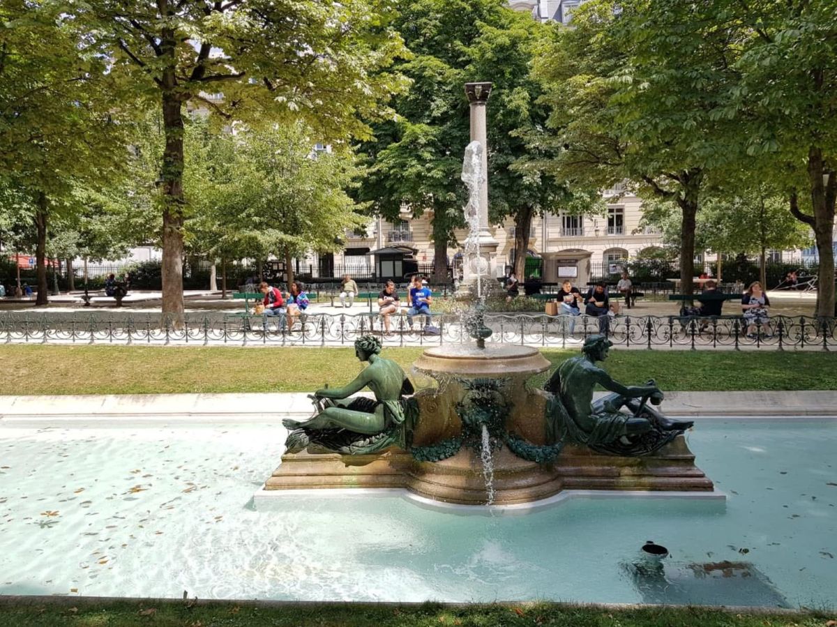
The Square Louise-Michel is located in the 18éme arrondissement of Paris, in the Grandes-Carrières quartier or neighborhood. Covering an area of 23,737 m², it is bordered by Place Saint-Pierre, Rue Ronsard, Rue Paul-Albert, Rue Maurice-Utrillo, Rue du Cardinal-Dubois, and Rue Foyatier. The Montmartre funicular, (see post) which opened in 1900, runs along the entire western side of the square. Two gentle horseshoe-shaped ramps lead to a lower terrace crowned by a balustrade. From this platform, straight stairs, oblique stairs on the sides and sloping paths on the periphery lead to the upper terrace surmounting the monumental fountain by Paul Gasq, a French sculptor, winner of the first Prix de Rome for sculpture in 1890, he was a resident of the Villa Medici in Rome from 1891 to 1894. Member of the Academy of Fine Arts from 1935. The name of the square refers to Louise Michel, one of the major figures of the Paris Commune of 1871. Located at the bottom of the Sacré-Cœur Basilica, the square is served by metro line 2 at Anvers metro station, and by line 12 at Abbesses station , as well as the Montmartre funicular.
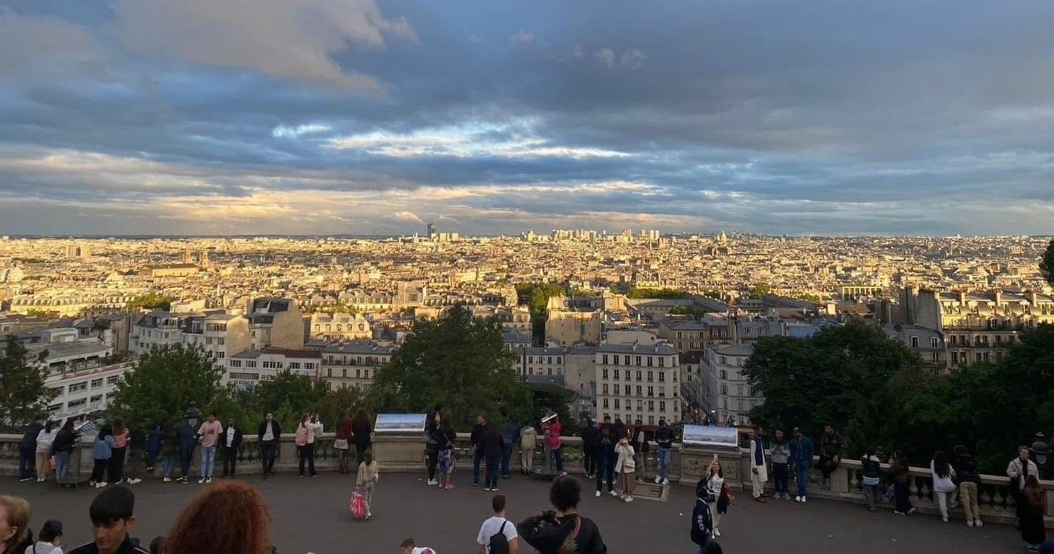
These lands were part of the domain of the Montmartre Abbey, which extended over the southern slope of the hill, sold as national property to quarrymen and building contractors in 1794 during the French revolution. A first small Saint-Pierre square, created at the foot of the hill, was opened to the public on April 3, 1877. In 1927, this square, once again remodeled, was finally inaugurated and took the name of Square Willette, named after Adolphe Willette, painter, illustrator, poster artist, lithographer and caricaturist, at the foot of the Sacré-Cœur basilica, a garden around a large staircase leading from the square to the basilica. The square Willette became, on February 28, 2004, the square Louise-Michel. Notable buildings here are the monumental fountain by Paul Gasq, in neoclassical style done in 1932 under the upper terrace, three semicircular niches with semi-dome vaults house a spout pouring water into basins decorated with pedestals sculpted with marine figures (Tritons, naiad), which overflow into a vast basin, Stone and bronze fountain known as the Innocents by Émile Derré, from 1906: a young mother supports her child while behind them little girls and boys enjoy themselves. The penis of the big baby, like the Manneken-Pis, emits a jet of water into the basin. The bronze figures reflect an idealistic image of happiness, reinforced by the engraved Rabelaisian maxim “Better to write with laughter than with tears”, The Allée de l’Île-des-Pins, this pedestrian path, which begins at the entrance to the square, on the rue Muller side, and runs along the rue Ronsard to the place Saint-Pierre, was named and inaugurated in March 2021, There are monumental trees by the square such as horse chestnut tree 20 meters high and 3.30 meters in circumference dating from 1902, Caucasian wingnut 20 meters high and 3.60 meters in circumference dating from 1899, American honey locust 3 meters in circumference dating from 1914, pomegranate tree, planted in 1952, height 3 meters, Oriental plane tree, planted in 1857, height 28 meters, circumference 520 cm, Osage orange tree planted in 1922, height 26 meters, circumference 375 cm also, araucaria; fig tree; ginkgo biloba and magnolia; The Venetian Carousel of Montmartre located at the bottom of the grand staircase is a contemporary, two-story fairground ride, manufactured by the Bertazzon factory (a ride manufacturer based in Italy. The American subsidiary produces bumper cars, carousels, flying chairs, music express, scenic ride vehicles and orbiters.) in the style of the 18C,
The City of Paris on the square Louise Michel : https://www.paris.fr/lieux/square-louise-michel-1762
The Paris tourist office on the 18éme arrondissement de Paris : https://parisjetaime.com/eng/article/explore-paris-s-18th-arrondissement-a832
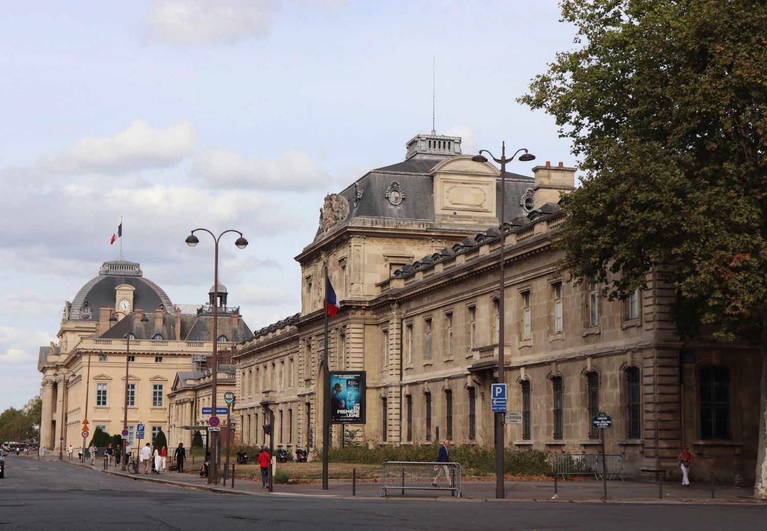
The place Joffre is located in the 7éme arrondissement of Paris. It separates the école militaire (see pic) and the Champ-de-Mars, between Avenue Duquesne and Avenue de La Bourdonnais, on the one hand, and Avenue de Suffren, the carrefour de General-Jacques-Pâris-de- Bollardière and Avenue de la Motte-Picquet, on the other hand, This square pays homage to Joseph Joffre Marshal of France, winner of the First Battle of the Marne in 1914 , He was Joseph Jacques Césaire Joffre, born January 12, 1852 in Rivesaltes in the Pyrénées-Orientales and died January 3, 1931 in Paris. The square takes his name in 1933, In the middle of the square is erected the bronze equestrian statue of Marshal Joffre inaugurated on June 10, 1939, The école militaire, Champ-de-Mars are located here,and the disused Champ de Mars metro station was located . A vestige of the metro entrance still remains, The parking Suffren-Joffre at corner of Avenue de Suffren and Place Joffre, is one of my favorite parkings in Paris! And the parking Joffre Ecole Militaire at Place Joffre corner with Avenue Frédéric le Play is good,also. and one of my favorites resto La Terrace du 7éme is nearby.(see posts)
The Paris tourist office on the 7éme arrondissement de Paris : https://parisjetaime.com/eng/article/explore-paris-s-7th-arrondissement-a825
The metro La Motte-Picquet – Grenelle (see pic) station is on lines 6, 8 and 10. The station is located at the intersection of Boulevard de Grenelle, Rue du Commerce and Avenue de La Motte-Picquet. The station owes its name to its location at the intersection of Avenue de La Motte-Picquet and Boulevard de Grenelle. The first track pays homage to Admiral Toussaint-Guillaume Picquet de La Motte , while the second refers to the former village of Grenelle until its annexation to Paris in 1860. Joséphine Baker in her song Revoir Paris (1949) quotes La Motte-Piquet: “Because without Paris, the Seine and the quays, and La Motte-Piquet, I feel that I was missing too many things.” The platforms are established: on line 6 (between Dupleix and Cambronne stations), east of the crossroads on Boulevard de Grenelle, overlooking its central reservation along an axis; on lines 8 (between Commerce and École Militaire, not including the current ghost station Champ de Mars from the second) and 10 (between Avenue Émile Zola and Ségur), north of the intersection and partially overlapping under the end of Avenue de La Motte-Picquet, along an axis. Upstream of the station, a service connection branches off at a point on the track of line 8 towards Balard, shortly after the exit of the ghost station Champ de Mars, to connect to the track of line 10 towards Boulogne – Pont de Saint-Cloud. On April 24, 1906, the aerial station (current line 6) was opened under the name of La Motte-Picquet with the commissioning of the second extension of line 2 Sud from Étoile (today Charles de Gaulle – Étoile) to Place d’Italie On October 17, 1907, line 2 Sud was absorbed by line 5, which then ran the route Étoile – Lancry (current Jacques Bonsergent station) On July 13, 1913, the station took its current name of La Motte-Picquet – Grenelle on the occasion of the opening of the underground stopping point at the central platform of line 8, on its first section between Opéra and Beaugrenelle (today Charles Michels). This is the current platform shared by lines 8 and 10 towards Créteil and Gare d’Austerlitz respectively. The station has five accesses: access 1 “Rue du Commerce” is at the end of the common area under the elevated station of line 6, and opens onto the central reservation of Boulevard de Grenelle at No 113; access 2 “Avenue de La Motte-Picquet” consisting of a fixed staircase decorated with a mast with a yellow “M” inscribed in a circle, located opposite No 65 of this avenue and only giving access to lines 8 and 10; access 3 “Boulevard de Grenelle” is at the end of the space under the viaduct of line 6, and is located on the central reservation of this boulevard at No 123 on the north side and No 126 on the south side; access 4 “Rue de Pondichéry”, consisting of a fixed staircase providing access only to lines 8 and 10, opening opposite No 66 of avenue de La Motte-Picquet; access 5 “Avenue de Suffren” also consisting of a fixed staircase providing access only to lines 8 and 10, located at No 52 of avenue de La Motte-Picquet. The elevated station of line 6 is of standard configuration: it has two platforms 75 meters long separated by the metro tracks. On the other hand, the underground station has a particular configuration: on the upper level are the tracks of lines 8 and 10 heading north on either side of a central platform, measuring 105 and 75 meters in length respectively, as well as the track of line 10 towards Boulogne located in a half-station separated by a pier, comprising a single track with a side platform measuring 105 meters in length, a unique case on this line. On the lower level, under this track, is the half-station of line 8 heading south, also with a single platform and track, 105 meters in length.
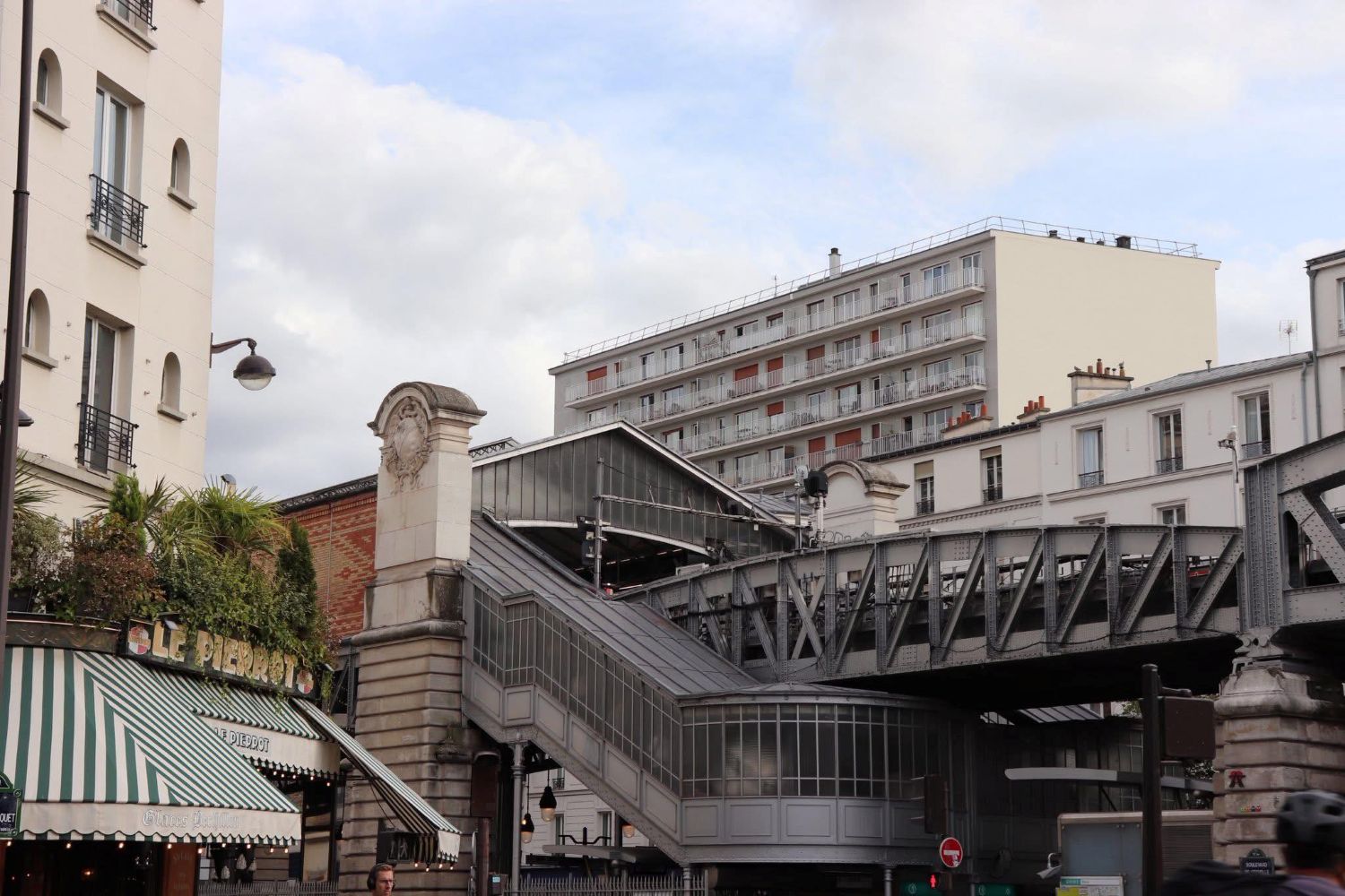
The metro station above is along the Boulevard de Grenelle located in the 15éme arrondissement of Paris. The boulevard’s name refers to the former village of Grenelle, which it ran alongside. This site is served by the Cambronne, La Motte-Picquet – Grenelle, Dupleix, and Bir-Hakeim metro stations. Formerly, it was outside the former toll wall: Boulevard de Javel, for the section between the current Quai de Grenelle and Rue de Lourmel; Boulevard de Grenelle, for the section between the current Rue de Lourmel and Rue du Commerce; Boulevard de Meudon, for the section between the current Rue du Commerce and Place Cambronne; Inside the former toll wall, the Grenelle rampart walk for the section between the current Quai Branly and Rue Daniel-Stern; part of the École-Militaire path, for the section between the current Rue Daniel-Stern and Place Cambronne. By decree of November 10, 1885, the section of Boulevard de Grenelle between Avenue de Breteuil and Place Cambronne was named “Boulevard Garibaldi.” Notable buildings here are at No. 1: headquarters of the Gros-Caillou sportif. The Vél’ d’Hiv’ tobacconist’s, a café-tabac run by Daniel Dousset (a cyclist, track specialist, then cyclists’ agent) in the 1950s. No. 10: headquarters of Le Parisien newspaper since 2017. No. 55: in 1958 the film Ascenseur pour l’échafaud by Louis Malle was filmed. Nos. 59 to 63: location of the Grenelle barrier, sometimes called the Ministers’ barrier. No. 87: headquarters of the French Football Federation; No. 99: Admiral Philippe de Gaulle was born here in 1921 (a French naval officer and politician. Son of General Charles de Gaulle and Yvonne de Gaulle), No. 131: Latinist, archaeologist, historian and translator André Boulanger lived at this address
The Paris tourist office on the 15éme arrondissement de Paris : https://parisjetaime.com/eng/article/explore-paris-s-15th-arrondissement-a827
The RATP IDF region transports on line 6 : https://www.ratp.fr/en/plans-lignes/metro/6
The RATP IDF region transports on line 8 : https://www.ratp.fr/en/plans-lignes/metro/8
The RATP IDF region transports on line 10 : https://www.ratp.fr/en/plans-lignes/metro/10
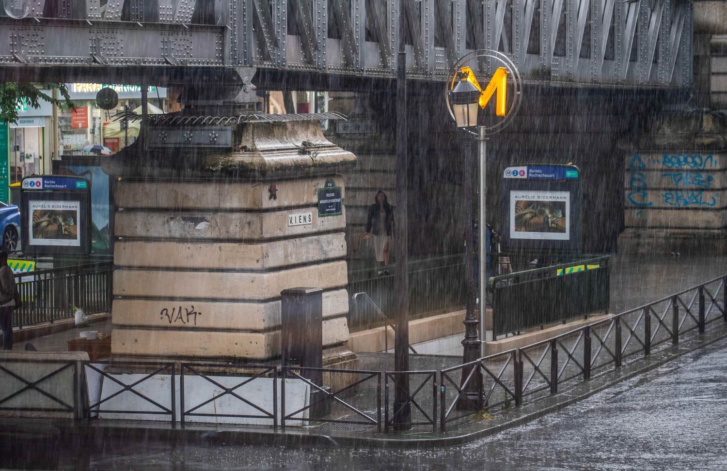
The metro Barbès – Rochechouart is located on metro lines 2 and 4 on the border of the 9éme, 10éme, and 18éme arrondissements of Paris. Also, in the boundary of the quartiers or neighborhoods of Rochechouart,Saint-Vincent-de-Paul, Clignancourt,, and the Goutte-d’Or . It is located at the intersection of four different boulevards: Boulevard de Magenta , Boulevard de la Chapelle, Boulevard Barbès , and Boulevard Marguerite-de-Rochechouart The platforms are located: on line 2, as a viaduct over the central reservation of Boulevard de la Chapelle on Line 4, underground and curved along the axes of Boulevard Barbès and Boulevard de Magenta, The Line 2 stop is located between Anvers and La Chapelle stations, while being separated from the latter by the Paris-Nord outstation, hence the use of a viaduct on this section of the line (between Anvers and Colonel Fabien stations) to span this obstacle. This is the fourth and final elevated station on the line towards Porte Dauphine. The Line 4 station is bordered by Château Rouge and Gare du Nord stations, the latter being preceded by a service connection with Lines 2 and 5, branching off at the tail end onto the track towards Bagneux – Lucie Aubrac. Representing the longest connection on the network, it also provides access, via the former terminal loop of Line 5, to the Gare du Nord USFRT station, closed to the public since the extension of the latter line to Église de Pantin in 1942. This station now provides training for Paris Metro drivers. The station has five entrances divided into six entrances and exits: Access No. 1, “Boulevard de Rochechouart,” consists of a fixed staircase, opening south of the central reservation of Boulevard Marguerite-de-Rochechouart, opposite No. 1 of the latter, along the western end of the Line 2 viaduct; Access No. 2, “Boulevard de Magenta,” also consists of a fixed staircase, located north of the same reservation opposite No. 2 of Boulevard Marguerite-de-Rochechouart; Access No. 3 “Boulevard Barbès” includes an entrance and an exit located on either side of the elevated station of Line 2, on the central reservation of Boulevard de la Chapelle, located respectively to the right of the Le Louxor cinema which forms the corner with Boulevard de Magenta (at No. 170 of the latter) and the Brasserie Barbès which is located at the corner with the eponymous boulevard (at No. 2 of the latter); Access No. 4 “Boulevard de la Chapelle” constitutes the main entrance to the station, arranged in the form of a wide staircase leading to the elevated platforms of Line 2, at the western end of the central reservation of Boulevard de la Chapelle; Access No. 5 “Rue Guy-Patin” includes a single exit from the eastern end of the common area under the Line 2 viaduct, on the central reservation of Boulevard de la Chapel at the end of Guy-Patin Street. Inaugurated under the name Boulevard Barbès, it took its current name of Barbès – Rochechouart on October 15, 1907. The station owes its initial name of Boulevard Barbès to its proximity to the aforementioned road, which pays homage to the French politician Armand Barbès. The name Rochechouart, added on October 15, 1907, comes from the proximity of Boulevard de Rochechouart (now Boulevard Marguerite-de-Rochechouart), whose name honors the nun Marguerite de Rochechouart de Montpipeau.
The RATP IDF region transports on line 2: https://www.ratp.fr/plans-lignes/metro/2
The RATP IDF region transports on line 4: https://www.ratp.fr/plans-lignes/metro/4
The Paris tourist office on the 18éme arrondissement de Paris: https://parisjetaime.com/eng/article/explore-paris-s-18th-arrondissement-a832
The Square Émile-Chautemps, formerly Square des Arts-et-Métiers, is located in the 3éme arrondissement of Paris. This square is located between Boulevard de Sébastopol, Rue Salomon-de-Caus, Rue Papin and Rue Saint-Martin opposite the Conservatoire national des arts et métiers (see post). This square honors the doctor of medicine, deputy, senator, and then minister Émile Chautemps. It is accessible by 98 bis, Boulevard de Sébastopol. It is served by metro lines 3 and 4 at the Réaumur – Sébastopol station. The square was created in 1858 by Davioud, as part of the transformations of Paris under the Second Empire (Napoléon III), The square covers 4,069 m2, and you can see a bust of Marc Seguin (author unknown), opposite the Conservatory. Bronzes by Charles Gumery (Agriculture and Industry) and Auguste Ottin (Mercury and Music) adorn the center of the pools, the ornaments by Michel Liénard. Column in Jura granite commemorating the French victories of the Crimean War (Inkermann, Sevastopol, Alma and Tchernaïa engraved on the four sides). Grilles framing the pools come from the Place de la République after its redevelopment. This garden is the first square in Paris designed “à la française”, according to the wishes of Napoleon III. It was in the 17C that the “à la française” style reached its peak, represented by André Le Nôtre, undoubtedly the master par excellence of French gardens. This success went beyond the borders of the kingdom of France and soon all the courts of the world wanted their French garden, even the Emperor of China and the Tsar of Russia!
The City of Paris on the square Emile Chautemps : https://www.paris.fr/lieux/square-emile-chautemps-2421
The Paris tourist office on Paris Centre (former arrond 1-4) : https://parisjetaime.com/eng/article/explore-the-centre-of-paris-a846
There you go folks, a dandy city to explore and enjoy with the family, Memorable moments in my eternal Paris, driving and walking all over in my road warrior trails brings out sublime awesome spots with nice memorable family visits of yesteryear always remember and always looking forward to be back, eventually. Again hope you enjoy the post on curiosities of Paris , part L !!! as I.
And remember, happy travels, good health, and many cheers to all !!!
