
As said, we come by here always, we eat here , enjoy it here ,ride boats here, and do shopping galore on many items yet I need to tell you more,with new pictures from my latest round in town always here but sometimes need to tell you more for you and me, I will tell you a bit more on favorites spots in my capital City of Vannes, in my beautiful Morbihan dept 56, in my lovely Bretagne, and in my belle France. Therefore, here again the curiosities of Vannes , part XXXIV !!! Hope you enjoy it as I
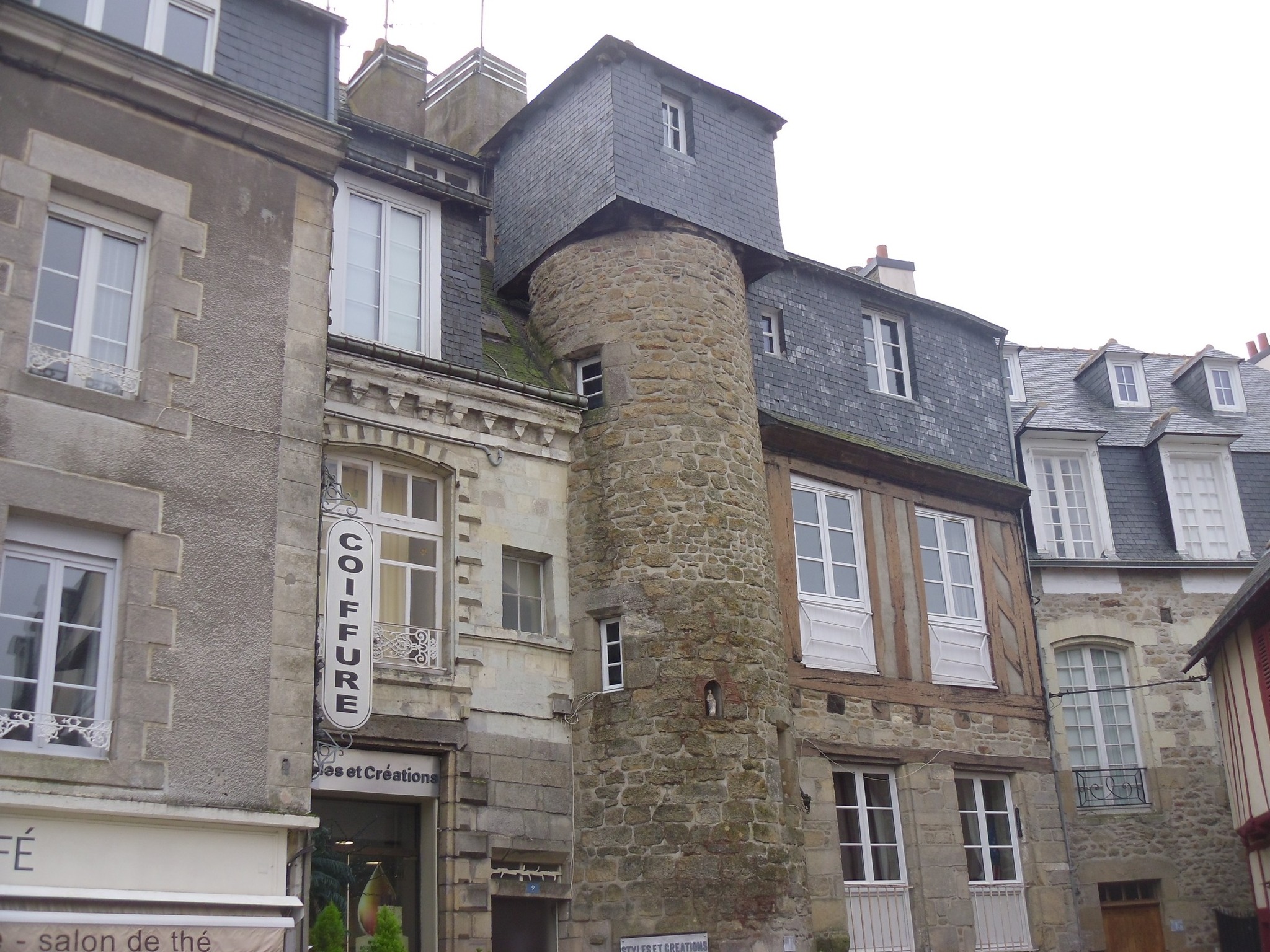
At no 9 Place des Lices is difficult to know what remains of the 17C in this house, whose façade was entirely rebuilt in the 18C. The quality of the stonework, granite on the ground floor and limestone on the upper floor, as well as the care taken with the large first-floor window and the cornice, suggests a wealthy patron, despite the small size of the plot which limited the house’s potential for expansion. The records of the 1677 land survey, drawn up for the adjoining buildings, attribute this house and the one extending from it onto the Place du Poids Public to the heirs of Pierre Bigaré, Lord of La Landelle. Likely originally half-timbered, the façade was rebuilt in granite and limestone in the 18C, according to its current architectural features. See my post on the Place des Lices,
The City of Vannes on the Place des Lices : https://www.mairie-vannes.fr/place-des-lices
The Rue du Port, formerly Rue de la Terre de Kaër, is mentioned as early as the 14C, whose houses then housed merchants whose activities were linked to the port. In the second half of the 17C, the arrival of the Parliament of Brittany in Vannes led to the reconstruction of some of the old houses, not only for the nobility but also for wealthy merchants. The irregular layout of this street in its southern section was rectified during the alignment plan of 1840: it was applied only to two houses in the center of the street and to the house located at the southern end. The houses occupy the west side of the street, the east side being bordered by the Promenade de la Rabine. Most of the houses are built on through lots of medieval origin between Rue du Port and Rue du Drézen. The house whose street-facing section was rebuilt for Grégoire Guillo Dubodan, a lawyer at the Présidial court, in 1696 according to the date inscribed, on a medieval plot. The rear section of the old house remains, as well as the 17C cut-stone well in the courtyard. According to 17C records, nos 6 and 8 belonged to the same owner; indeed, they still share a courtyard. The two houses were divided between the Sieur de Larmor, an allied family, and the Sieur de Guillo Dubodan in 1695. No 8 was rebuilt around 1950; the ground floor of No 6 was modified in the 19C. See the pic on the very good Créperie du Port ;32 Rue du Port , and see post with more of the Rue du Port,
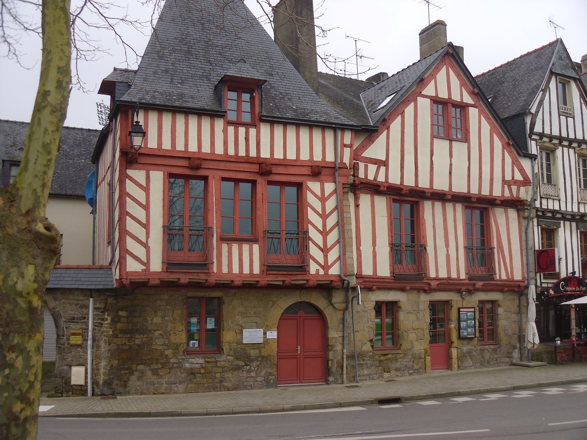
The Rue Thiers, formerly Rue des Douves du Port, was part of a vast urban project which, in addition to creating the square, included the realignment and straightening of Rue du Port and Rue des Douves du Port, which would become Rue Thiers, as well as the opening of a new street ,Rue Autissier connecting the square to Rue des Bons Enfants, today Rue Richemont. It was on February 4, 1879, that a prefectoral decree officially named it Rue Thiers This was during the construction of the grain market. Partly constructed on gardens on the west side, the street’s layout did not affect the old town, as it ran alongside the bastion that served as a garden for the Hôtel de Bazvalan, which was only demolished during the construction of the post office (now the Crédit Agricole bank). By incorporating the layout of the Place de la République,(see post) home to the grain market, an emblematic building of Vannes’ economic activity at that time, Rue Thiers acquired an urban dimension it lacked in the 18C plan. Indeed, the Hôtel de Limur,(see post) standing alone in the middle of the street, granted it this major status. This dimension was further accentuated by the construction of the new City/town hall on the Place du Marché,(see post) from which Rue Thiers begins. It was only in the second half of the 20C that the street was fully built, The replacement of the large grain market by the current post office (see post) in 1950 further blurred the street’s image. At 1 Rue Thiers there is a Merchant’s house built in the latter part of the 16C. The date 1663, inscribed on the right-hand side wall of the second floor of the neighboring house during the wall’s raising, suggests that some alterations were made at that time. It may have been an inn under the Ancien Régime (monarchy). This gable-fronted house, facing the street, is built on a medieval-style L-shaped plot. It is timber-framed, with a rubble stone north side wall; the ground floor and first floor of the south side wall are rubble stone, while the second floor is timber-framed. It has two full stories served by a spiral staircase enclosed within a circular timber-framed stairwell at the junction of the two sections. On the ground floor, the projecting counter to the left of the door indicates that the ground-floor room was used as a shop. On Rue du Drézen, the partially subterranean ground floor was a cellar or storeroom. It was formerly the home of the association “The Most Beautiful Bays in the World.” It is now under renovation,

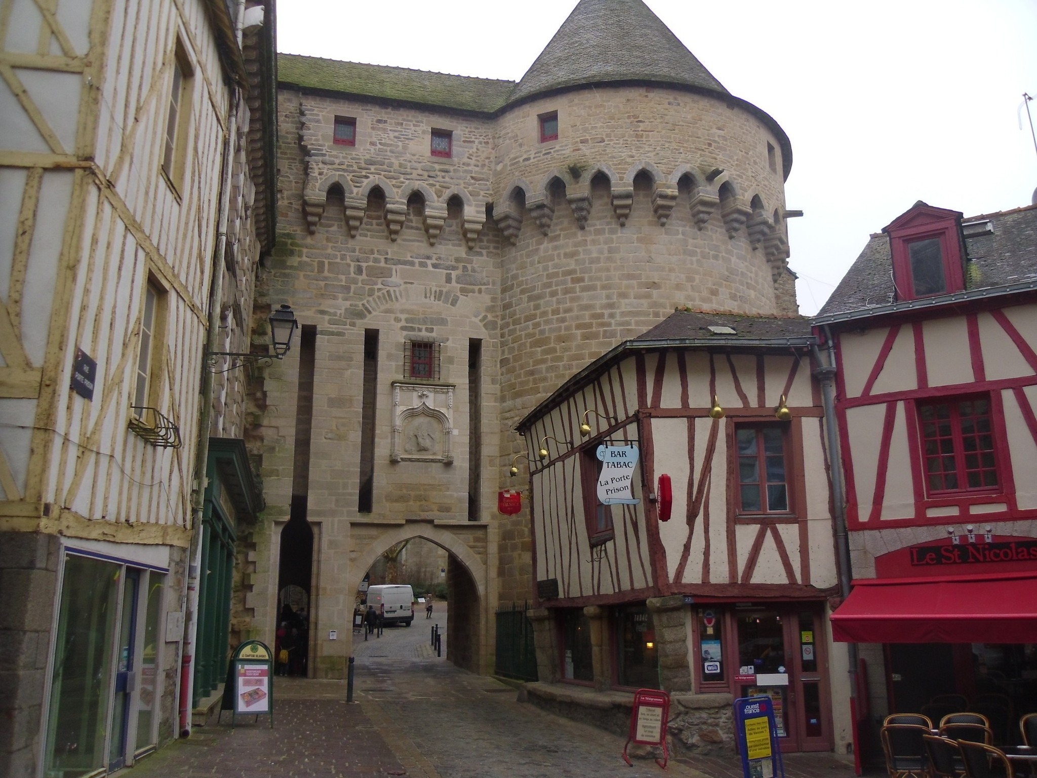
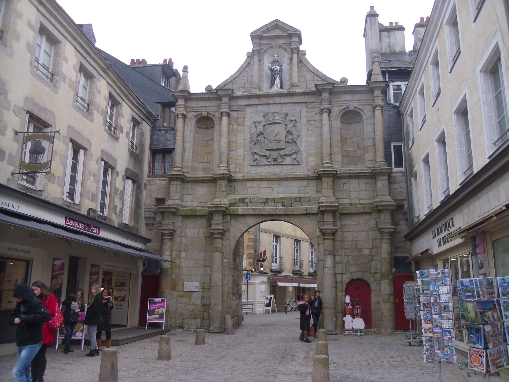
The old Roman road crossing the castrum from west to east likely passed very close to the gate, which is believed to have provided access to the city from the 3-4C onwards from the Saint-Patern neighborhood. This neighborhood developed on the Boismoreau hill, where the ancient city extended before its confinement within the fortified walls. Evidence of this can be seen in the remains of the Gallo-Roman wall still standing near the gate, on Rue Francis Decker.(see post) A medieval building stands at the site of this ancient city gate. It was erected in the 13C, under John II (Jean). This first phase of construction included the gate itself and the front section of its passage, closed by a portcullis. The second phase took place under John IV, (Jean) during the second half of the 14C. The gate was equipped with a drawbridge, a postern for pedestrian access, and a large, low relieving arch above it. The third phase is attributed to John V.(Jean), the Porte Prison consisted of the reconstruction of the upper sections, enhanced with machicolations on corbels forming pointed arches. This gate, known as the Prison Gate, formerly the Saint-Patern Gate, is located on Rue Porte Prison According to ancient texts, the gate was also reinforced at this time with a barbican, an advanced defense designed to protect entrances made more vulnerable by the advancement of artillery. Under Francis II or Anne of Brittany, a sculpted shield bearing the arms of Brittany was inserted between the grooves of the drawbridge. From the end of the 18C to the beginning of the 19C, the gate served as a place of incarceration for men and then took the name of Prison Gate. In 1886, the south tower was demolished except for part of its ground floor and the exterior facing of its lower level which serves as a support for the neighboring house.
The ramparts of Vannes protect the old town and are the result of a long process of construction and development between Late Antiquity and the modern era. Around the middle of the 3rd century, the ancient city was surrounded by its first wall on the Mené hill to protect itself from invasions; this first wall, which still partially survives, maintained a relatively stable layout for several centuries. The route of the wall is better known to the north, along the streets Thiers, Francis Decker, de Closmadeuc, and du Mené, while its southern orientation seems to have followed the northern and western boundaries of the present-day Place des Lices to reach Rue Saint-Salomon. Five gates then provided access to the walled city: Saint-Patern, Saint-Salomon, Bali, Saint-Jean, and Mariolle. The construction of the Château de l’Hermine in the 1380s incorporated the new city walls, and work continued until the end of the century, particularly to the west near the Cordeliers monastery. Two new gates were opened to the south, Calmont and Gréguennic, and several towers were erected in the 15C, including the Executioner’s Tower, the Powder Tower, and the Joliette Tower. During the Wars of Religion at the end of the 16C, the city reinforced its defenses by adding polygonal bastions such as Gréguennic, Brozillay, Haute-Folie, and then La Garenne, and created an opening to the south to serve the port district, the future Saint-Vincent Gate. In the 17C, the ramparts underwent modifications to facilitate traffic flow and accommodate urban expansion, particularly with the establishment of the Parliament of Brittany and several convents. The Poterne and Saint-Jean gates were created, and the Saint-Vincent gate was restored, The construction of new roads and a lack of maintenance in the 18-19C led to the partial demolition of walls and gates; the Prison Gate was partially destroyed in 1886. For several decades, excavation and restoration campaigns have allowed for the reconstruction of numerous sections of the curtain wall and fortifications, and some buildings built against the ramparts now house cultural activities. Among the remarkable remains are structures from different periods: the Prison Gate (late 14C), the Constable’s Tower (15C), the Saint-Vincent Gate (16-17C), and the Saint-Jean Gate (17C), as well as bastions and towers from the second set of walls. With a significant portion of its original length preserved, the Vannes fortifications are among the best-preserved in Brittany and constitute a major element of the city’s heritage and tourist appeal. See posts on all of them in my blog,
The City of Vannes on the Porte Prison : https://www.mairie-vannes.fr/porte-prison
The Porte Calmont along the Trompette Tower alleyway. The new city wall, begun at the end of the 14C by John IV (Jean), included two new gates to the south, leading to the port district: the Gréguennic Gate and the Calmont Gate. The latter takes its name from the suburb it serves, which is the starting point for the journey to the Rhuys peninsula along the coast via Séné and the Saint-Armel passage. This gate retains traces of the original drawbridge system, which included two drawbridges with counterweights: deep grooves cut into the wall above each gate, which still retain the drawbridge shafts when raised. At the base of both passages, the holes that held the drawbridge axles are visible. The wide recess beneath the central passage provided access for unloading goods transported by boat to the foot of the wall. The gate’s construction also included, to its left, the building of a three-story tower. Its top floor has been removed, where, beneath the roof, there was an upper room surrounded by a covered walkway resting on the machicolations. The tower has a lower room (now filled in) pierced by a gunport facing the port and a guardroom with a fireplace and a second gunport facing the Château de l’Hermine (see post). Two separate doors in the alley provide access to these rooms. On the top of the curtain wall, to the right, one can still see the corbels that, in the 16C, supported the half-timbered guardhouse, built on a cantilever over the moat. Between 1616 and 1619, the gate received an advanced defense, some of whose foundations still support the garden on the Rue Alexandre Le Pontois side. It was closed in 1625 in favor of the new Saint-Vincent gate,(see post), which opened onto the port. The Calmont gate underwent restoration in 1992, allowing pedestrians to once again use it via a footbridge spanning the Marle river, which connects to Rue Saint-Vincent thanks to the clearing of a narrow alley. (lovely to walk under it) In 2008, the outer facing of the curtain wall was restored.
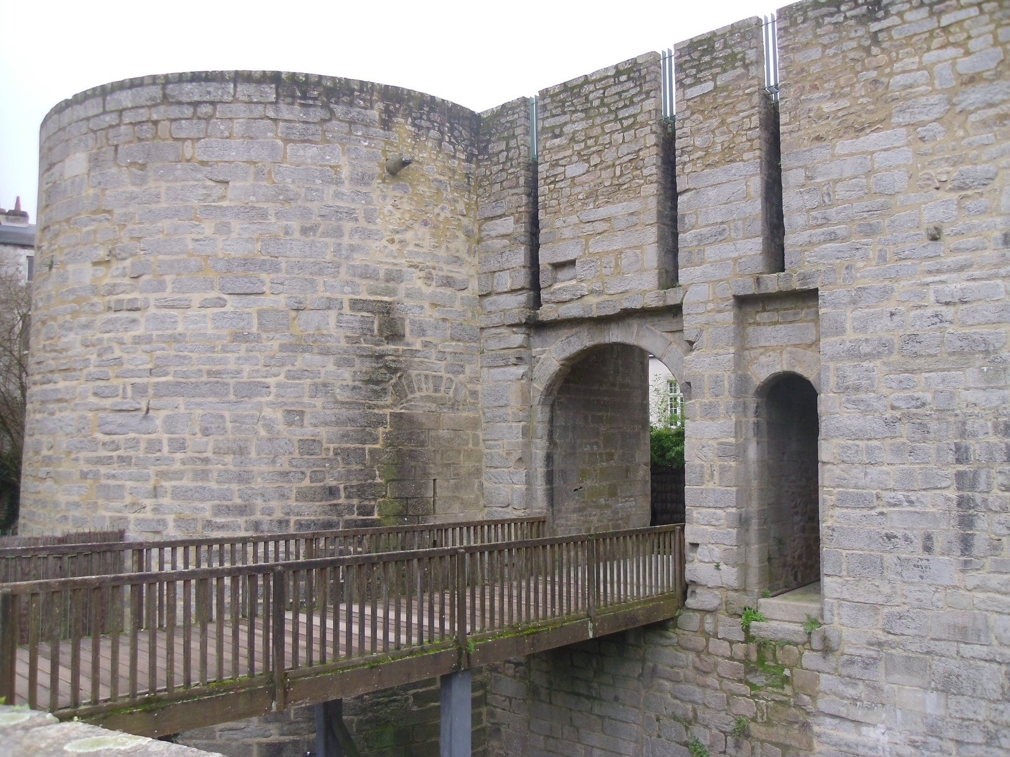
The City of Vannes on the Porte Calmont : https://www.mairie-vannes.fr/porte-et-tour-de-calmont
The Porte Saint-Vincent (Gate),at rue Saint-Vincent facing place Gambetta (see post). We know that a passage was first opened at this location in 1600 to replace the Gréguennic Gate, which was unusable due to the bastion built in 1593. This new opening was then called the Ker-Calmont Gate, The current gate followed, completed between 1620 and 1624. The structure showed serious signs of deterioration from the beginning of the 18C. Repairs were carried out in 1727. In 1747, the gate was completely rebuilt preserving the façade but removing the roof and the upper chamber. A first statue of the saint, made of stone or marble, was installed in 1624, to honor the city’s patron saint, the preacher Saint Vincent Ferrer, who died in Vannes in 1419, This statue, destroyed during the French revolution, and replaced with that of a sans-culotte. In 1891, the current statue was installed in 1891. It was restored in 2019. On the same date, the city’s coat of arms was affixed to the façade. The coat of arms is described as “Gules, a silver ermine passant, collared and buckled silver, with an ermine neckline and gold border.” It is supported by “two silver greyhounds, collared gules, edged and ringed gold.” These two greyhounds are a reminder of those that King Francis I of France presented to the city when he came to Vannes on August 4, 1532, for the treaty of perpetual union of Brittany with France. Initially, a count’s coronet surmounted the coat of arms. However, in 1891, this coronet was replaced by a mural crown with three towers. This new design of the coronet recalls that Vannes is the prefecture of Morbihan. Below this coat of arms is the motto of Vannes, “A ma vie” (For my life). This motto was that of the Order of the Ermine before becoming that of the city of Vannes. It should be noted that the Order of the Ermine was a chivalric order founded in 1381 by John(Jean) IV, Duke of Brittany, following the Battle of Auray.(see post) This battle, part of the Anglo-French rivalry of the Hundred Years’ War, was the last battle of the Breton War of Succession. The granite ashlar doorway is architecturally designed with three bays framed by columns and three levels. On the lower level, the carriage entrance is flanked by two narrow bays, one blind, the other with a pedestrian door. Two niches open on the second level in the side bays, framing the city’s coat of arms. The third level consists of a central niche framed by volutes.
The City of Vannes on the Porte Saint Vincent : https://www.mairie-vannes.fr/porte-saint-vincent
The city of Vannes on its heritage : https://www.mairie-vannes.fr/decouvrir-le-patrimoine-vannetais
The Morbihan dept 56 tourist office on Vannes : https://morbihan.com/decouvrir/le-morbihan-et-ses-perles-bretonnes/destination-golfe-du-morbihan/vannes-entre-art-et-histoire/
The Local Gulf of Morbihan tourist office on Vannes : https://www.golfedumorbihan.bzh/explorer-vannes/decouvrir-vannes/golfe-morbihan/vannes/
The Bretagne region tourist office on Vannes:https://www.brittanytourism.com/destinations/the-10-destinations/southern-brittany-morbihan-gulf/vannes/
There you go folks, something nice around beautiful architecture and wonderful history I love it ,never tired of visiting Vannes !! Again, hope you enjoy this post on the curiosities of Vannes, part XXXIV !!! as I.
And remember, happy travels, good health, and many cheers to all !!!

It reminds me of my recent visit to Vannes last summer, when it gets hot quickly when the sun is shining. For a while, the ramparts were considered an obstacle to urban expansion. Unfortunately, part of them has been lost, but what remains is well preserved.
LikeLiked by 2 people
Gladly that they are preserved its a testimony to French architecture and history we keep very precious. Thanks for stopping by Cheers
LikeLiked by 1 person