
And of course, mentioned in many posts in my blog. However, really needs more like a post of its own. This is the mighty beautiful Seine river of Paris! So many stories, too long to have in one post even one blog!! but I would give you my humble contribution and tell you a bit more on the Seine river of Paris !!! Hope you enjoy the post as I
I had realized not written much or nothing on the Seine river!! This is the best most glamorous river of France, and not just because it passes by Paris. It goes a long way thru some wonderful towns big and small and full of history and things to see. In Paris is it just romantic, wonderful, great, gorgeous well you get it right! This is the best most glamorous river of France, and not just because it passes by Paris. In Paris is it just romantic, wonderful, great, gorgeous well you get it right! It has 37 bridges passing over it, and I have written a piece on the bridges of Paris and the Seine in general . Today Paris has 34 bridges over the Seine and 4 pedestrian walkways. The Charles-de-Gaulle bridge (1996) and the Léopold-Sedar-Senghor (1999) and Simone-de-Beauvoir (2006) footbridges are the last works built. More into Paris proper, the Seine cuts Paris in its midst even if the right bank(rive droite) occupies a space more important than the left bank( rive gauche). In Paris, its length occupies nearly 13 km, with a depth varying between 3.40 and 5.70 meters. Its width varies from 30 to 200 meters. The normal holding of the reach of Paris, i.e. the altitude of the surface in relation to the sea level, is about 27 meters.
The Seine river has a length of 777 km, which flows in the Parisian basin and covers Troyes, Paris, Rouen and Le Havre. Its source is located 446 meters altitude from Source-Seine, in Côte-d’Or dept 21 region of Bourgogne Franche Comté , on the plateau of Langres. Its course has a general orientation from the southeast to the northwes , finally flowing into the channel between Le Havre and Honfleur. Its watershed, with an area of 79 000 km2, is of interest to nearly 30% of the country’s population. The Seine is divided into five parts, upstream in Aval: The petit Seine (little seine), from the source to Montereau-Fault-Yonne (confluence with the Yonne); La Haute Seine (upper seine), from Montereau-Fault-Yonne to Paris; The crossing of Paris; The Basse Seine,(lower seine) from Paris to Rouen; and The Seine maritime, (marine or ocean seine) from Rouen to La Manche.
The artificial lake of the Forêt d’Orient, up Stream of Troyes, and the lake of Der-Chantecoq upstream of Saint-Dizier were created in the years 1960 to 1970 to regulate the flow of the river. The sources of the Seine are the property of the city of Paris since 1864. An artificial cave was built the following year to house the main source and the statue of a nymph symbolising the river. It also houses the remains of a Gallo-Roman temple (now buried). Objects testifying of the cult to the sources of the river (Dea Sequana) are exposed to the Archaeological Museum of Dijon. Here is a list of the main tributaries (greater than 100 km, or basin greater than 1 000 km2 ) known to the nearest confluence direct from the Seine and located with their confluence by distance (km) with the western boundary of the Seine estuary : These are the Oise, Marne, Yonne, Eure, Aube, Loing, Risle, Essonne ,Epte,and Yerre. The regions and departments crossed are the following, going from the source to the mouth: In the region of Bourgogne-Franche-Comté: la Côte-d’Or; In the France Est region: The Aube and the Marne; In the Île-de-France region: Seine-et-Marne, Essonne, Val-de-Marne, Paris, Hauts-de-Seine, Seine-Saint-Denis, Val-d’Oise and Yvelines; In the Normandie region: Eure, Seine-Maritime and Calvados (along the extreme end of the mouth).
The Seine river in Paris today has only two real islands: the Ile de la Cité and the Ile Saint-Louis. The Ile de la Cité did not take on its present appearance until the beginning of the 17C, during the construction of the Pont Neuf, on the occasion of which the Islets of the Gourdaine, aux Juifs, and des Vaches. Île Saint-Louis was originally called Notre-Dame when it was cut in half by a canal in the middle of the 14C. As a result, the upstream islet took the name of Ile aux Vaches and the downstream islet kept the name of Notre-Dame. The two islands only regained their unity in the first years of the 17C, and then became a new residential area. The name of Saint-Louis was given to it in 1725, replaced by that of Fraternity during the French revolution.
Today, the Seine river no longer provides drinking water to Parisians, since the surface water used comes from Evry and Orly, far upstream. About 40 bouquinistes ( booksellers) have settled on the banks of the Seine, right bank as left bank, since the 17C with varying fortunes depending on the period. Fixed barges or péniches are also the place of residence of certain Parisians. On the banks of the Seine, there are many walks, as well as, on certain portions of both the right bank and the left bank, a expressway for motor vehicles. In the fall of 2012, the right bank lane was redeveloped to make the waterfront accessible to pedestrians. Since the spring of 2013, the lower track on the left bank from the Musée d’Orsay to the Pont de l’Alma has been redeveloped into a pedestrian zone equipped with various facilities such as benches, game tables, restaurants, floating gardens, pools, etc. Since the summer of 2002, for a little over a month each year, the Paris Plages operation has hosted various events in the middle of sandy beaches and potted trees.
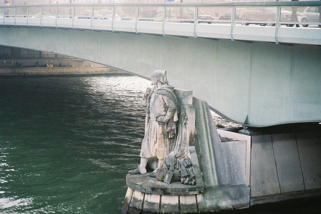
In Paris, the floods are measured since 1876 by a hydrometric scale installed at the Pont d’Austerlitz (Austerlitz Bridge) , nevertheless it is the statue of the Zouave of the Pont d’Alma (Alma bridge) which remains the most popular. This indicator during the flood of January 1910, water reached on this scale the record height of 8.68 meters ( I guess an ecological disaster but we never heard anything much of it ::)) . Since 1870, the height is taken at the train station Austerlitz. The oldest known floods of the Seine were narrated by Julien (358AD) and Grégoire de Tours (582AD ). The next modern one in May to June 2016, the Seine experienced an important flood. The water level peaks at 6.10 meters on the night of June 3 to 4. It’s the biggest flood in Paris for over 30 years. However, it does not exceed the 6.18 meters of the 1982 flood. The last one of 2018 recorded 5,86 m on January 28 at 22h30. And certain transport infrastructures, in particular the RER C are submersible in the event of a major flood.
The Seine maritime as well as part of the lower Seine are subjected to the tidal regime, which goes up to the dam of Poses in the Eure (60 cm tidal wave). It was still possible to observe in the 1960’s an imposing wave that could reach 4 meters at the time of the great tides and called Mascaret, more locally a Barre. The phenomenon reached its maximum in Caudebec-en-Caux, about halfway between Le Havre and Rouen. For Mariners and river Navigation Services, the Seine is broken down into: “Petite Seine” from Marcilly-sur-Seine to Montereau-Fault-Yonne; “Haute Seine” from Montereau-Fault-Yonne to Paris; “Seine parisienne” inside Paris; “Basse Seine” from Paris to Rouen; and “Seine maritime” from Rouen to the sea. The Seine is navigable on a large part of its course. The responsibility for navigation belongs to the waterways of France (VNF) until Pont Boieldieu in Rouen, and in particular to the navigation Service on the Seine upstream of Amfreville-sous-les-Monts. On the other hand, it does not include the Parisian canals (Canal de Ourcq, Canal Saint-Denis and Canal Saint-Martin) which are managed by the city of Paris.
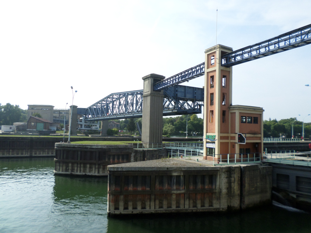
Between Rouen and Paris, the Seine was channeled in the 19C. Seven lock dams located in Poses-Amfreville-sous-les-Monts, Notre-Dame-de-la-Garenne (Eure), Méricourt, Andrésy, Bougival, Chatou (Yvelines) and Suresnes (Hauts-de-Seine) allow the navigation of self-propelled barges (350 tons of freight) Self-propelled Freicinet template boats of 38.5 meters, self-propelled river barges (from 800 to 1 350 tons of cargo), 48 to 70 meters, thrust barge convoys (3 000 to 10 000 tons freight) and Sea-River coasters (4 000 tons of freight). These barges carry, among other things, containers, automobiles, petroleum products, cement, etc.
The port facilities located in Île-de-France belong to the autonomous port of Paris, the first French river port. The main port facilities for freight traffic are located in Limay (Yvelines) and Gennevilliers (Hauts-de-Seine). The Seine has inspired many painters, and in the19C and 20C , Honoré de Balzac described the Seine from every angle. Gustave Flaubert uses the Seine as a metaphor for the linear flow of time, the symbol of narrative progress. Many poets, French and Francophone, sang the Seine. All too numerous to mention but huge names of all times.
Move into Paris proper, the Seine river cuts Paris in its midst even if the right bank(rive droite) occupies a space more important than the left bank( rive gauche). In Paris, its length occupies nearly 13 km, with a depth varying between 3.40 and 5.70 meters. Its width varies from 30 to 200 meters. The normal holding of the reach of Paris, i.e. the altitude of the surface in relation to the sea level, is about 27 meters. In Paris, the Seine is crossed by 37 bridges, including four footbridges accessible only to pedestrians.
The course of the Seine is dotted with many sights. Near Paris a springs from the Seine to Source-Seine; Châtillon-sur-Seine with the numerous tributaries of the Seine, its ancient streets and the Vauclusian source of the Douix; Troyes and its ancient city center with its Churches and Cathedral; Moret-sur-Loing, which is close to the confluence of the Loing with the Seine and the painters; Thomery and the Forest of Fontainebleau; Paris, and the the banks of the Seine. The levies of Suresnes (see post) just across from one of my earlier jobs in France are awesome and just across the Bois de Boulougne.
Outside Paris we have Bougival and its Frog Park (parc de la Grenouillére) on the island of Bougival (île de Bougival) , whose extension is the island of Chatou (île de Chatou) ; Chatou and its Maison Fournaise, rendezvous of the Impressionists and often painted by them; Conflans-Saint-Honorine and the Musée de la Batellerie (river boat building) (Yvelines); Poissy and its 12C Collegiate Church, where King St. Louis (Louis IX) was born and baptized; Mantes-la-Jolie and its 12C Collegiate Church; La Roche-Guyon and its castle (Val-d’oise), where the comic writer Edgar P. Jacobs has located one of the adventures of Blake and Mortimer, The Diabolical Trap; Giverny and the House of Claude Monet (Eure); The Andelys and the Château-Gaillard; Rouen, the medieval town (Seine-Maritime); Caudebec-en-Caux and the Church of Notre-Dame de Caudebec-en-Caux, masterpiece of flamboyant Gothic and Renaissance; The Tancarville Bridge; The Pont de Normandie; Honfleur and its port; Le Havre rebuilt by the architect Auguste Perret after WWII.
A bit of history I like tell us that the Seine river would have captured the old course of the Bièvre river from the Pont ’Austerlitz to the Pont de l’Alma. The two rivers would have swept the silts that separated them between the current train stations of Lyon and Austerlitz and the arm of the Seine east of the current Marais district was gradually filled. The current confluence of the Bièvre and the Seine was thus formed east of the Sainte-Geneviève hill in a delta marsh between two arms of the Bièvre leading to the location of the current bridges of the l’Archevêché and Austerlitz . After having wandered, the confluence would have established itself upstream from the Pont d’Austerlitz. The pillar of the Nautes, kept at the Musée national du Moyen Âge des Thermes de Cluny in Paris, reminds us that navigation on the Seine was already intensive in the first years of the Roman conquest. In 1170 the corporation of water merchants received from King Louis VII the monopoly of commerce on the Seine. On their seal is the boat which is still in the coat of arms of the city of Paris. In August 9, 1803, experimentation of Robert Fulton’s steamboat was done on the Seine. The first bateaux-lavoirs or laundrymat boats were anchored in the Seine in 1851, and quickly reached the hundred. The arrival of running water in Parisian buildings led to their gradual disappearance until 1937. The Line 4 of the metro was the first to cross the Seine underground, in 1908.
The new Avisbat to inform you of trafic on the navigable rivers of France: https://avisbat.vnf.fr/avisbat/accueil
The Seine in the city of Paris: https://www.paris.fr/pages/la-seine-2406
The Paris tourist office on the Seine destinations: https://parisjetaime.com/eng/discover-paris/paris-by-theme/destination-seine-paris-rouen-le-havre-i102
The Paris tourist office on cruising on the Seine: https://parisjetaime.com/eng/things-to-do-in-paris/tours-and-cruises-paris/cruises-paris-i151
The Paris tourist office on walks along the Seine river: https://parisjetaime.com/eng/article/paris-river-seine-a921
There you have it folks, the wonderful mighty Seine river of Paris, You could not come to Paris without walking its quays and the boat rides , they are a must; indeed a magical body of water on a magical city of the world, Paris and beyond !!! The Seine? It is the most beautiful boulevard in Paris! Seen from the river, Paris is totally different. The river exudes something deeply sensory, which I miss when I have to sleep on land !! Seine, Paris or Paris Seine one in all, Eternal Paris !! Again, hope you enjoy this post on the Seine river of Paris !!! as I.
And remember, happy travels, good health, and many cheers to all !!!


