
I found them!! Its not easy to find pictures that are in several modes from paper to usb to cd roms but finally got to these ones. I like to have it in my blog and hope you enjoy it as much as I. This is going back deep back in my life when as a boy lived in Havana or La Habana or San Cristobal de la Habana! I remembered walking a lot around the main points there and was able to visit again as recently as 2012 to see it one more time before it really goes dilipated. I like to tell you my side of the Bay of Havana!
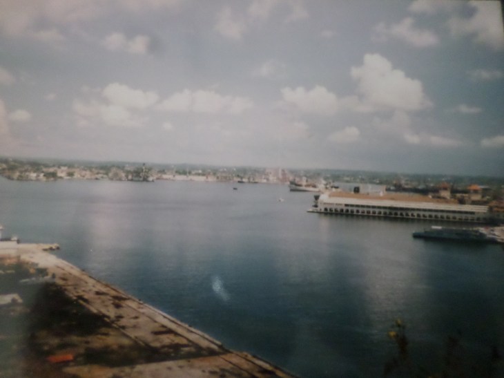
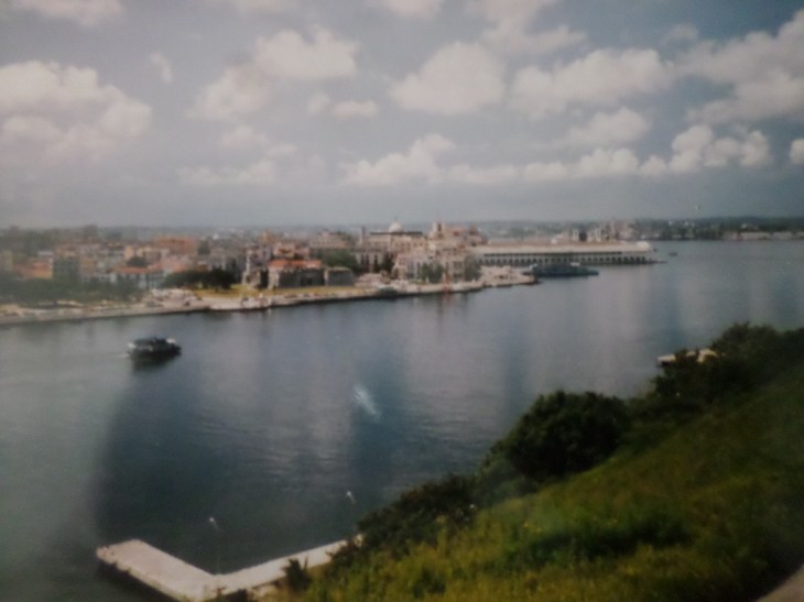
The Bahia de la Habana or Havana Bay is the bay around which stretches Havana, the capital of Cuba. Havana Bay is considered one of the safest bays in the Caribbean and America. It has a strategic geographical and economic location due to its confluence with the Straits of Florida, the Gulf of Mexico and the old channel of the Bahamas. It is navigable only in 120 meters and has 87 percent of the occupied territory, and 63 percent of the productive sector with 71 berths and 50 docks. The bay which actually forms a roadstead extends over 5 km2 communicates with the Caribbean Sea through a channel 1.2 km long and approximately 220 meters wide. There are coves on the outskirts with the 3 main ones being the Marimelena, Guanabacoa and Atarés. There is a wonderful road tunnel inaugurated in 1958 makes it possible to cross the entrance of the bay. This tunnel appeared there between the seven wonders of the French civil engineering. Underneath the bay of Havana for 733 meters, and a depth of 15 meters, was built by the French company Société de Grands Travaux de Marseille. It was inaugurated exactly on May 31 1958.
The bay of Havana is bordered by the towns/neighborhoods of Habana Vieja (old Havana), Regla , and La Habana del Este or (East Havana). Since the second half of the 16C, the entrance to the bay has been protected by two fortresses: El Morro to the east and San Salvador de la Punta to the west.
The constant attacks by corsairs and pirates during the first years of the 16C, as well as the constant expansionist sieges of France, England and Holland, forced the Spanish Crown to establish a defensive system to protect the location of the bay and its port. Then important fortifications arise such as the Castillo de la Chorrera, located at the mouth of the Almendares River; the Castillo de la Punta , the Castillo del Morro , the Castillo de la Real Fuerza and the San Carlos de La Cabaña Fortress, built after the attack and capture of Havana by English troops in August 1762. This system of fortifications was joined by the construction between 1674 and 1797 of the Wall of Havana, which divided the city into two zones. It was from 1561, with the decision to concentrate the Fleet of the Indies in the Port of Havana before its trip to Spain, that the city began a flourishing development and with it the establishment of the first residential nuclei and public buildings to along the coast of the Port.
My personal take as it was my city…long ago ok. If you start from the Malecon next to the castle of San Salvador de la Punta (for short La Punta) you will see the monument to the medicine students of 1871 killed by Spain under the colonial rule. Continue you see the Monument to Maximo Gomez (hero of independence war vs Spain) , and arrive at the nice park Parque Céspedes. Follow by the smaller park parque Luz Caballero right in the corner on calle Empedrado street you see the remains of the ramparts wall of Havana! And next you see the Castillo de la Real Fuerza de la Habana (for short La Fuerza) , after you turn right into calle Narciso Lopéz to see the El Templete or small temple the spot of the first Catholic Mass in Cuba! You continue along the bay street and you see on your right the nice jardin de la Princesa Diana de Gales (princess Diane of Wales garden) ; quickly follow by the back of the Lonja or bourse commerce stock exchange from colonial times. You quickly see the square or Plaza Francisco de Asis and the wonderful Basilica San Francisco de Asis or St Francis of Assisi. Further to see in my opinion is still bordering the bay on your right hand side the Iglesia de San Francisco de Paula or the Church of St Francis of Paula. Then, further down along the bay you reach to the back of the Estacion Central de Ferrocarriles or Central Train Station of Havana, and further on your right you will end the walk with the Castillo de Atàres or Atares castle.
If you start across the bay at the point you will be at the Castillo delos Tres Reyes del Morro (Morro castle for short). You would go up on the esplanade to reach the Fortaleza de San Carlos de la Cabaña (for short la Cabaña). Right here by the esplanade they still do the 21h or 9pm cannon shot announcing the closing of the bay of Havana and a bit further You will go up to the Cristo or Christ . Afterward you will reach the town of Casablanca . Here there is a ferry boat that takes back to Havana central or the other town on the bay that of Regla. However I heard this was in disrepair so not sure if still doing the runs.
There is no specific webpage for the Bay of Havana the above taken from my books on my Havana. However, if you follow my guide above on foot you will be delighted to see the beauty or at least recognised the beauty of old in the new Havana. Hope you enjoy the post and see my other posts on Havana in my blog.
And remember, happy travels, good health, and many cheers to all !!!
