
We have driven and walked in my eternal Paris, and would like to have an imprint in my blog on the wonderful family times we had there, There is so much to see , doing my best, and glad found me this picture in my cd rom vault ,which now transposing in my blog for you and me, This was my former worked city, so glad to post more memorable spots on it, I thank you for your readership over the years and to bear with my rants! After Paris is to rant, shout and yelled about, me think. Therefore, here is my take on curiosities of Paris, part XLII !!! Hope you enjoy the post as I.
The Lycée Chaptal or Chaptal high school is named after the scientist, chemist, physician, and politician Jean-Antoine Chaptal, It is located at 45 Boulevard des Batignolles in the Europe quartier or neighborhood of the 8eme arrondissement or district of Paris, separated by Rue de Rome from the railway tracks running below that serve the Saint-Lazare train station, the site is served by the metro stations Rome line 2 and Villiers line 2 and 3. The upper, middle, and lower secondary schools occupy separate plots of the new monumental complex, each with a courtyard surrounded by classrooms and a dedicated entrance. Covered galleries connect them and provide access to the common areas (gymnasium, cafeteria, etc.). The main entrance is located on Boulevard des Batignolles, where the administration is also located; In neo-Romanesque and neo-Renaissance style, this polychrome façade is about a hundred meters long. The school complex is framed by square towers topped with lanterns. On the colossal avant-corps on the Batignolles side, the inscriptions “Industrie” and “Commerce” appear, while the pediment is decorated with a bust of the goddess Athena. The final year classes are essentially scientific with four classes preparing for the scientific baccalaureate – including one with engineering sciences as a determining subject. A fifth class prepares for the economic and social baccalaureate. Created under the name of Institut Saint-Victor institution, it was first installed between rue Blanche and rue de Clichy. It was renamed école François-Ier school in 1844 ,then Chaptal municipal college in 1848. In 1863, the college’s board of directors unanimously supported its move to the site of a 13,500 m2 garden located between boulevard des Batignolles, rue de Rome, rue Bernoulli and rue Andrieux. The project began during the reign of Napoleon III. The work lasted from 1866 to 1876, with an interruption due to the war of 1870 to 1871. The first intake at Batignolles took place in 1874, although the work finished two years later. The old site of rue Blanche and rue de Clichy was destroyed. The land has since hosted the Casino de Paris. In 1950, the collége Chaptal or middle school became the Lycée Chaptal or high school.

The Boulevard des Batignolles is located in the 8éme and 17éme arrondissements of Paris. Starting from the Place de Clichy and extending to the Place Prosper-Goubaux, it separates the 8éme arrondissement from the 17éme arrondissement. In the middle of this wide, two-lane boulevard are planted trees, some of which are two hundred years old. Pétanque enthusiasts come to play there. This long pedestrian walkway begins with the Promenade Aristides-de-Sousa-Mendes and ends in the Place de Clichy with the Promenade Cécile-Chaminade. This site is served by the metro stations Villiers lines 2 and 3, Rome line 2 and Place de Clichy lines 2 and 13. It is named after the former village of Batignolles which it ran alongside. Formerly, it was: outside the old toll wall the boulevard des Batignolles, inside the old toll wall the Clichy patrol path , On this boulevard were once the barriers of Monceau, of the Reformation and of Clichy. Having taken several thousand photographs alongside his literary activity, the writer Émile Zola, at the end of the 19C, took one, with pedestrians in the rain, at the intersection of rue de Rome and boulevard des Batignolles ,Notable buildings on it are at No. 43: Pont de l’Europe car park, set up in one of the halls of the former courier services of the Saint-Lazare train station, built in 1919. No. 44: Batignolles temple, built in 1898 and a member of the United Protestant Church of France. No. 45: Lycée Chaptal, public institution (see above). No. 56: former Polish School of Batignolles (1842-1874) then Teacher Training College of Paris (from 1874), now the building of the National Higher Institute of Teaching and Education (INSPÉ Paris). No. 78: Hébertot Theater, 17éme arrondissement side, opposite the Promenade Jacques-Hébertot. No. 80: formerly the Relais des Batignolles, restaurant where the actor Jean Marais beat up the collaborationist journalist Alain Laubreaux on June 12, 1941, for his defamatory remarks about Jean Cocteau. This violent scene was reproduced by François Truffaut in his film Le Dernier Métro in 1980.
The quartier Europe or neighborhood covering 118.3 hectares, is rich in buildings representative of the 19C avant-garde. Many artists,poets and painters resident and even found inspiration here: Manet painted the Chemin de fer, Monet the Gare Saint-Lazare, and Caillebotte the Pont de l’Europe. Appreciated for its greenery and the expanse of its parks such as Parc Monceau, Square Marcel Pagnol, and Square Louis XVI, the quartier Europe is the most residential of the 8éme arrondissement. The Racine, Chaptal, and Fénelon high schools, as well as the Regional Conservatory of Music, welcome students from the arrondissement, and the numerous artisanal music shops on Rue de Rome delight instrumentalists and musicians from all over the city. The 8éme arrondissement City/town hall, housed in the prestigious Hôtel Cail, is located on Rue de Lisbonne.
The official collége et Lycée Chaptal :https://pia.ac-paris.fr/serail/jcms/s2_1584188/fr/college-et-lycee-chaptal
The Paris tourist office on the 8éme arrondissement de Paris : https://parisjetaime.com/eng/article/explore-paris-s-8th-arrondissement-a826
The Paris tourist office on the 17éme arrondissement de Paris : https://parisjetaime.com/eng/article/explore-paris-s-17th-arrondissement-a831
The Gare du Nord (see posts), also known as the Paris-Nord, is the Parisian head of the railway network serving the north of France, as well as the neighboring countries. Because of the proximity of Belgium, the Netherlands, Great Britain and Germany, it has always possessed a marked international vocation, before its regional traffic has developed strongly. It is, with an endowment of thirty-two lanes at the quays since 1993, of which four underground, the station Gare du Nord occupies, in France, the first place in traffic. The metro station Gare du Nord, where lines 4 and 5 pass with a connecting corridor underground station to the metro station La Chapelle of line 2. These are the exits/sorties when coming out of the Gare du Nord Exit or Sortie 1 Rue du Faubourg Saint Denis, 2 Rue de Saint Quentin, 3 Rue de Dunkerque, and 4 Boulevard de Denain. On the surface and in the bus station you can find the buses: Lines 26, 30, 31, 35, 38, 39, 42, 43, 46, 48, 54, 56, 65, 302, 350 ,etc, The memorable Café du Nord at 19 rue de Dunkerque for many days of drink and snacks on the run passing by the train station on my way to Belgium,
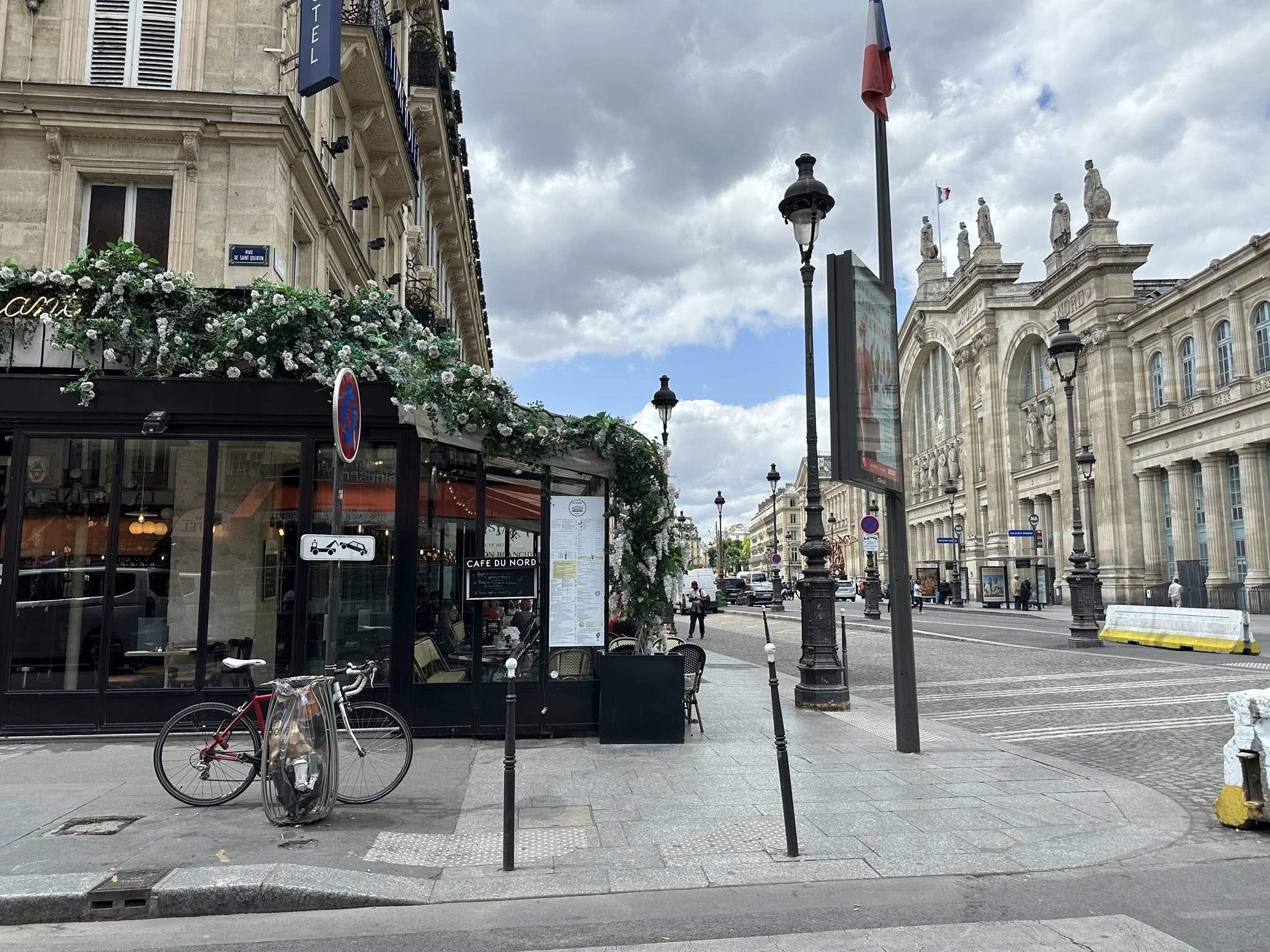
The Rue de Dunkerque is in the 9éme and 10éme arrondissements of Paris. It begins at 43, rue d’Alsace and ends at 12, place d’Anvers and 39, boulevard de Rochechouart after crossing the streets of La Fayette, du Faubourg-Saint-Denis, de Saint-Quentin, the place Napoléon-III, the boulevard de Denain, Compiègne, de Maubeuge, Saint-Vincent-de-Paul, the boulevard de Magenta, of Rocroy, du Faubourg-Poissonnière, de Rochechouart, the avenue Trudaine and the rue Gérando. This street owes its name to the town in the Nord department no 59, Dunkerque, served by the Gare du Nord. The first section of the street, with a total length of 552 meters, is drawn between the streets of Faubourg-Saint-Denis and Faubourg Poissonnière. The street was called Rue des Abattoirs, because it headed towards the Montmartre slaughterhouses, was then part of the old 3éme arrondissement of Paris, quartier Faubourg-Poissonnière neighborhood. The Rue du Faubourg-Saint-Denis,continues through an old dead end, called “cul-de-sac Saint-Lazare” or “impasse des Abattoirs” which leads to the fodder market of Faubourg Saint-Martin. The second section of the street was opened in 1839 between Rue de Rochechouart and Rue du Faubourg-Poissonnière. This street was called rue Neuve-du-Delta. Its name refers to the fact that the street is laid out on the site of the Jardin du Delta, a resort and entertainment center similar to the Tivoli Gardens, which closed in 1824. The street was then part of the old 2éme arrondissement of Paris, quartier Faubourg-Montmartre neighborhood. A decree of September 6, 1853 provided that the partially open street in the extension of the rue de Dunkerque to communicate from the rue du Faubourg Poissonnière to the rue Rochechouart, opposite the avenue Trudaine, is classified as one of the public streets of the city of Paris. In 1847, the rue des Abattoirs was renamed rue de Dunkerque due to its proximity to the Gare du Nord. Notable buildings here even if not directly on it is the Gare du Nord , (see pic) At no. 29: Ciné Nord cinema. Opened in 1930, it was initially a neighborhood cinema. In the 1980s, it became a pornographic cinema with two screens. It was one of the last cinemas of this type in Paris. It closed in 2013. A theater replaced it after renovation, the today Théâtre de la Boussole.
The official SNCF Gare du Nord: https://www.garesetconnexions.sncf/en/stations-services/paris-gare-du-nord
The Paris tourist office on the Gare du Nord : https://parisjetaime.com/eng/transport/gare-du-nord-p1935
The Paris tourist office on the train stations of Paris : https://parisjetaime.com/eng/article/paris-train-stations-19th-century-architectural-heritage-a027
The Paris tourist office on the 10éme arrondissement de Paris : https://parisjetaime.com/eng/article/explore-paris-s-10th-arrondissement-a843
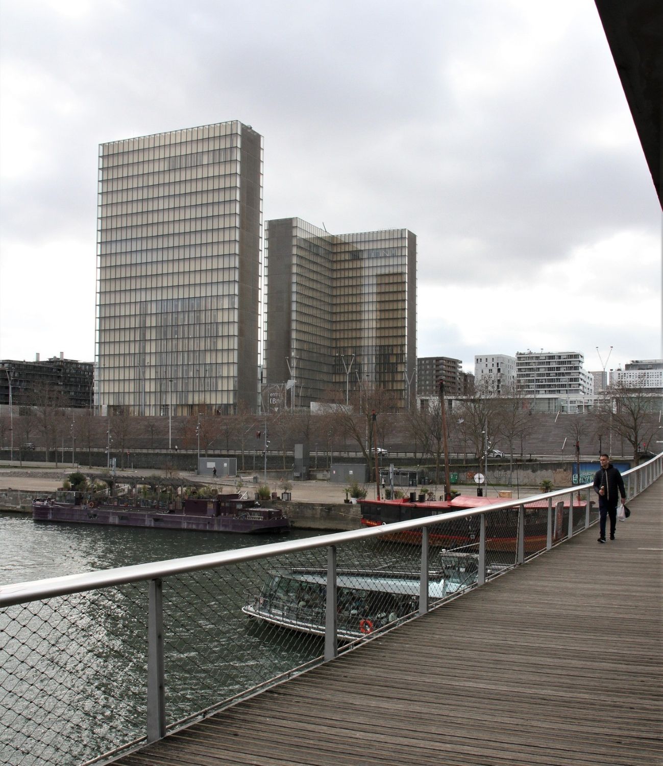
The Passerelle Simone-de-Beauvoir or footbridge is reserved for so-called “soft” modes of transport (pedestrians, bicycles). It is the 37th bridge over the Seine in Paris. It is located between the Bercy and Tolbiac bridges and connects the banks of the 12éme and 13éme arrondissements of Paris, of approximately 304 meters. This site is served by the Quai de la Gare line 6 metro station. In March 2005, it was named after the French philosopher, novelist, letter writer, memoirist and essayist, Simone de Beauvoir, and inaugurated on July 13, 2006 in the presence of Sylvie Le Bon de Beauvoir, daughter of Simone de Beauvoir. The entrance channel of the Ivry water station, work on which began in May 1764, would be located approximately at the location of the Simone-de-Beauvoir footbridge. Its five spans cross the river without support in the water and join the tracks on the high bank directly on the forecourt of the François-Mitterrand library, left bank,(see pic), and directly in the Bercy Park, right bank, with double supports on the lower banks of the Quai François-Mauriac, left bank, and Quai de Bercy, right bank.
The Paris tourist office on the passerelle Simone de Beauvoir : https://parisjetaime.com/eng/transport/passerelle-simone-de-beauvoir-p1867
The Paris tourist office on the innovations of the 13éme arrondissement de Paris : https://parisjetaime.com/eng/article/at-the-heart-of-innovation-in-the-13th-arrondissement-a777
There you go folks, a dandy city to explore and enjoy with the family, Memorable moments in my eternal Paris, driving and walking all over in my road warrior trails brings out sublime awesome spots with nice memorable family visits of yesteryear always remember and always looking forward to be back, eventually. Again hope you enjoy the post on curiosities of Paris , part XLII !!! as I.
And remember, happy travels, good health, and many cheers to all !!!
