
In my dear gorgeous Versailles ; there are many places other than the castle. The city needs to be seen more, my kind of town, actually did lived there for 9+ glorious years! Very nice family memories. I found me older paper pictures that again should be in my blog, Walk it back way back and see natural beauty of the once Domaine de Versailles ! Therefore, here is my take again on the Domaine de Versailles, part II !!! Hope you enjoy the post as I
The first mentioned of Versailles dates from 1038 where monks erect a Church of Saint Julien. By 1472 , the first complete mentioned of the city is as Versailles-aux-Bourg-de-Galie (new French, Versailles in the town of Gally). It has been a long and illustrious story of my dear City of Versailles, One of the grands of our world, a must to visit when in France or even to come just for it!! The domaine de Versailles is the set of lands and buildings of 850 Ha. (8000 Ha before the French revolution) including the Palace of Versailles. You do the math as one hectare is equal to 2.471 acres. Besides the palace/museum, it includes today, 93 ha of gardens and 300 ha of forest. You count 20 km of enclosures, 42 km of alleys, and 372 magnificent statues ! The property goes back way back of the Grand Canal into the towns of St Cyr l’école and its many gates or portes that encircle the old Domain of Versailles for 43 km!!. These are the villages once part of the Domaine of Versailles and today ,towns of their own : Buc, Guyancourt, Bois-d’Arcy, Saint-Cyr, Fontenay-le-Fleury, Rennemoulin, Noisy, Bailly. It included the Satory plateau, the upper part of the Bièvres valley, the Villaroy plateau, the Saint-Quentin pond (on parts), the Bois d’Arcy plateau and the Versailles plain up to the edge of Villepreux to the west. The large park was bordered to the north by the Marly park. From the western end of the Grand Canal radiated five large avenues, several dozen meters wide, crossing the domaine’s park.
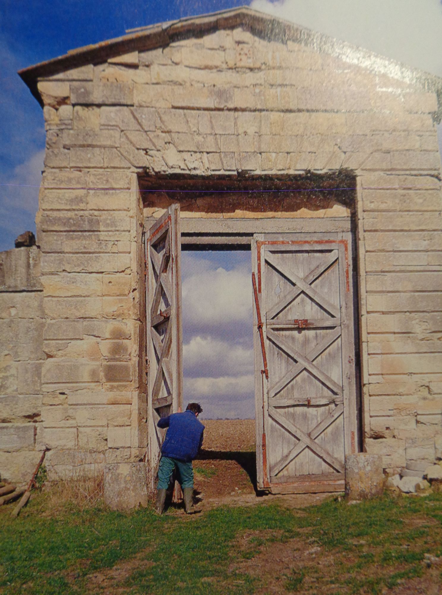
The Porte de Bailly or Porte de Maintenon (enclosure wall of the Petit-Parc) is located on the Allée Royale de Maintenon, its access allowed during hunting parties to reach the Grand-Parc, the forest or the castle of Marly, In the extension from the Allée Royale de Maintenon there was a last gate called the Grille de Maintenon. This alley linked the Etoile Royale to the Grille du Trou d’Enfer opposite the old castle of the Marly estate, the gate was, with the Porte de Noisy, one of the exits from the Palace of Versaillesduring hunting parties in the forest of Marly, Today, of the Porte de Bailly gate, only the two pillars remain. The allée de Bailly has been completely restored on its last section, starting at the foot of the Bassin du fer à cheval (horseshoe), The gate has been closed since 1999 ,and was the part furthest from the castle, at the very end of the large park. It was renovated in 1855-1857 with a new decor. You can find parking on the Bailly alley for cars only (paid access via the grille de la Reine). This is at the beginning of the alley that takes you way back to the gate, My favorite here was the Porte de Bailly still visible from the Ferme de Gally on St Cyr l’école (see post).
The ru de Gally is a 22 km long stream, tributary on the right bank of the Mauldre, and therefore sub-tributary of the Seine. Its source is in the parc domaine de Versailles east of the Ferme de Gally farm (see post), between the Grand Canal and the Grand Trianon. Downstream from the Gally farm, it crosses the town of Thiverval-Grignon and in particular the domain of the National Agronomic Institute Paris-Grignon as well as the Moulin de la Bonde in the town of Crespières before joining the Mauldre downstream from the town of Beynes, at a place called La Maladrerie (which I passed many time by car) In the department of Yvelines (78), the ru de Gally crosses thirteen towns, including Versailles, Saint-Cyr-l’École, Bailly, Fontenay-le-Fleury, Noisy-le-Roi, Rennemoulin, Villepreux, Chavenay, Davron, Thiverval-Grignon, Crespières, Beynes, and Mareil-sur-Mauldre. Many memories driving by them !

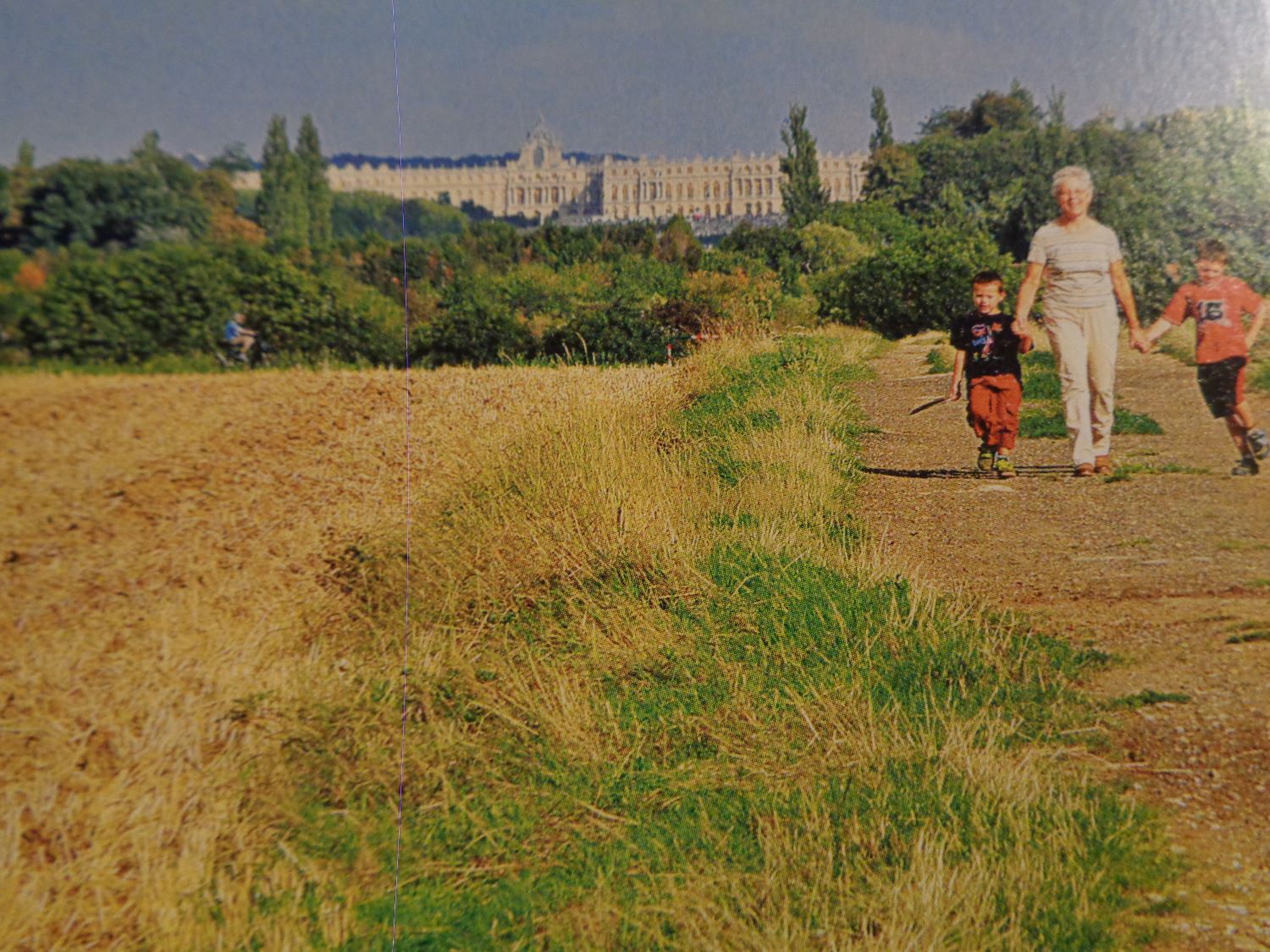
The Allée royale de Villepreux, created in 1680 by André Le Nôtre, gardener to Louis XIV and grand administrator of Versailles, it is at the centre of the Versailles plain. An extension of the Grand Canal, this axis is part of the “Grand Perspective” imagined by André Le Nôtre on either side of the palace. It starts at the Bassin d’Apollon with the Tapis vert, an esplanade that descends towards the Grand Canal. Beyond, the avenue starts from the roundabout known as L’Étoile Royale and crosses the towns of Versailles, Saint-Cyr-l’École, Fontenay-le-Fleury, Rennemoulin and Villepreux. The Allée royale was the main one of the five avenues that started in a bundle from the Etoile Royale, forming a majestic landscaped ensemble that was compared to “the hand of the King resting on his territory”. Originally, it was a grassy avenue 97 meters wide and 5 km long, bordered by a double row of elms. Cleared in its centre, it is framed on either side by two main 5 meters paths.
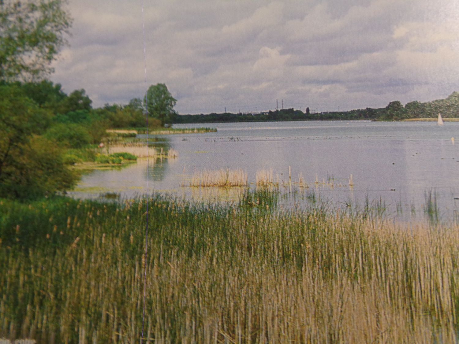
The étang de Saint-Quentin pond is located in the towns of Trappes and Montigny-le-Bretonneux ,and in the new city of Saint-Quentin-en-Yvelines, It will take the name of pond of Saint-Quentin, named after a chapel, (demolished in 1780) which would have welcomed the relics of Saint Quentin. The Saint-Quentin pond is an artificial pond with an area of approximately 150 hectares; It is the largest pond in Yvelines dept 78 . The body of water, connected to the Park de Versailles by the aqueduct of Trappes (cut in 1978), could by itself ensure a storage of 3 million m3. Its altitude is 160 meters. In the 17C, the park of Versailles, with ever more spectacular jets and fountains, needed ever more water. Around 1675, a specialist in leveling surveys, Abbé Picard, using a level with a telescope, noticed that the ponds located on the plateau of Trappes were higher than the reservoirs of Versailles. The work lasted from 1676 to 1691. An underground aqueduct brought the water from the pond to the Colbert reservoirs built in the Parc-aux-cerfs (not far from the current Versailles-Chantiers train station). All around the pond, there are royal boundary markers. The fleur-de-lys represented on the boundary markers is carved in relief in an oval. For some of them, it is a royal crown that adorns the stone. Sometimes these patterns are damaged or even illegible. They were broken or covered by the revolutionaries. These markers were used to delimit the water supply network of the Palace of Versailles and to identify the royal infrastructures. Note that of the original thousand, only about 200 remain today.
The official Château de Versailles on the ru de Gally : https://en.chateauversailles.fr/news/life-estate/ru-gally-stream
The official Château de Versailles on some walks in the domaine: https://en.chateauversailles.fr/discover/estate/gardens/walks#the-water-walk
The Versailles tourist office on the parc domaine de Versailles tour : https://www.versailles-tourisme.com/parcours-velo-la-plaine-de-versailles.html
The city of Versailles on history/heritage : https://www.versailles.fr/65/decouvrir-versailles.htm
There you go folks, one of the must to see in Versailles and worth it. Another masterpiece of my belle France, and hope you have the time to see it while at this huge property that is the Domaine de Versailles. Again, hope you enjoy this post on the Domaine de Versailles, part II !!! as I.
And remember, happy travels, good health, and many cheers to all !!!
