
 Other things to see here, me think are the Féodal Tour of the Domaine de la Salle: 12C watchtower located at a place called Lassalle 300 m from the village near the D 208 road. Old house of the castle, A Roman bridge on the old road from Puy-en-Velay. Another bridge 12C located at a place called La Bourdette 1 km west of the village near the D 931 road. A bridge which crosses the Osse river at the old water mill. There remains only one semicircular ark on the two which made up the bridge. Old Moulin à Vent located at a place called Le Moulin à Vent or at a place called Lassalle, 1 km east of the village near the D 208 road, on a hill behind the vines. Isolated mill of the circular tower type. A moulin à eau or water mill of the 12C located at a place called La Bourdette 1 km west of the village near the D931 Mill of the old priory, the base of the mill date from the construction of the bridge and the church. A lavoir and Fontaine or washhouse and fountain located at Place de la Bascule near the village.
A bit of history tell us that in the 10C, Mouchan was the seat of a doyen of the order of Cluny. During the Hundred Years War, the village underwent depredations due to the incursions of English troops. The Hundred Years War endowed the village of the watchtowers, ramparts, courtyards turrets and bridges.
The town of Mouchan on its heritage : https://www.mouchan.fr/un-site-a-decouvrir-commune-de-mouchan_fr.html
The official European Federation of Clunicians sites on Mouchan : https://candidature-patrimoine-mondial.sitesclunisiens.org/category-1-0-decouvrez-les-sites-candidats
The local Gers-Armagnac tourist office on Mouchan : https://en.gers-armagnac.com/explorer/sites-a-visiter-2/6925875_village-de-mouchan/
There you go folks, another spot in my world map or rather France’s map. Glad to have found the old pictures to give credit to Mouchan in my blog; good for the memories of always. Again, hope you enjoy the post on this is Mouchan as I.
And remember, happy travels, good health, and many cheers to all !!!
Other things to see here, me think are the Féodal Tour of the Domaine de la Salle: 12C watchtower located at a place called Lassalle 300 m from the village near the D 208 road. Old house of the castle, A Roman bridge on the old road from Puy-en-Velay. Another bridge 12C located at a place called La Bourdette 1 km west of the village near the D 931 road. A bridge which crosses the Osse river at the old water mill. There remains only one semicircular ark on the two which made up the bridge. Old Moulin à Vent located at a place called Le Moulin à Vent or at a place called Lassalle, 1 km east of the village near the D 208 road, on a hill behind the vines. Isolated mill of the circular tower type. A moulin à eau or water mill of the 12C located at a place called La Bourdette 1 km west of the village near the D931 Mill of the old priory, the base of the mill date from the construction of the bridge and the church. A lavoir and Fontaine or washhouse and fountain located at Place de la Bascule near the village.
A bit of history tell us that in the 10C, Mouchan was the seat of a doyen of the order of Cluny. During the Hundred Years War, the village underwent depredations due to the incursions of English troops. The Hundred Years War endowed the village of the watchtowers, ramparts, courtyards turrets and bridges.
The town of Mouchan on its heritage : https://www.mouchan.fr/un-site-a-decouvrir-commune-de-mouchan_fr.html
The official European Federation of Clunicians sites on Mouchan : https://candidature-patrimoine-mondial.sitesclunisiens.org/category-1-0-decouvrez-les-sites-candidats
The local Gers-Armagnac tourist office on Mouchan : https://en.gers-armagnac.com/explorer/sites-a-visiter-2/6925875_village-de-mouchan/
There you go folks, another spot in my world map or rather France’s map. Glad to have found the old pictures to give credit to Mouchan in my blog; good for the memories of always. Again, hope you enjoy the post on this is Mouchan as I.
And remember, happy travels, good health, and many cheers to all !!! This is Mouchan !!!
Several years back while visiting my belle France, took a ride into this area. Not aware had some older paper picture in my vault and glad to found them! Not back since but left a nice impression ,and hope to be back, eventually. Not the best quality pictures but is all I have for the memories of always. I like to tell you a bit about this town taking advantage of these much older pictures. Therefore, here is my take on this is Mouchan !!! Hope you enjoy the post as I.
The village of Mouchan is located in the dept of Gers no 32 in the Occitanie region of my belle France. On the historical and cultural level, the town is in the Condomois, a former district of the province of Gascogne having title of county. On the current RD 931, between Condom and Eauze. It is 72 km from Mont-de-Marsan, 109 km from Pau, 123 km from Toulouse, 141 km from Cahors, 657 km from Versailles and 641 km from my current house,
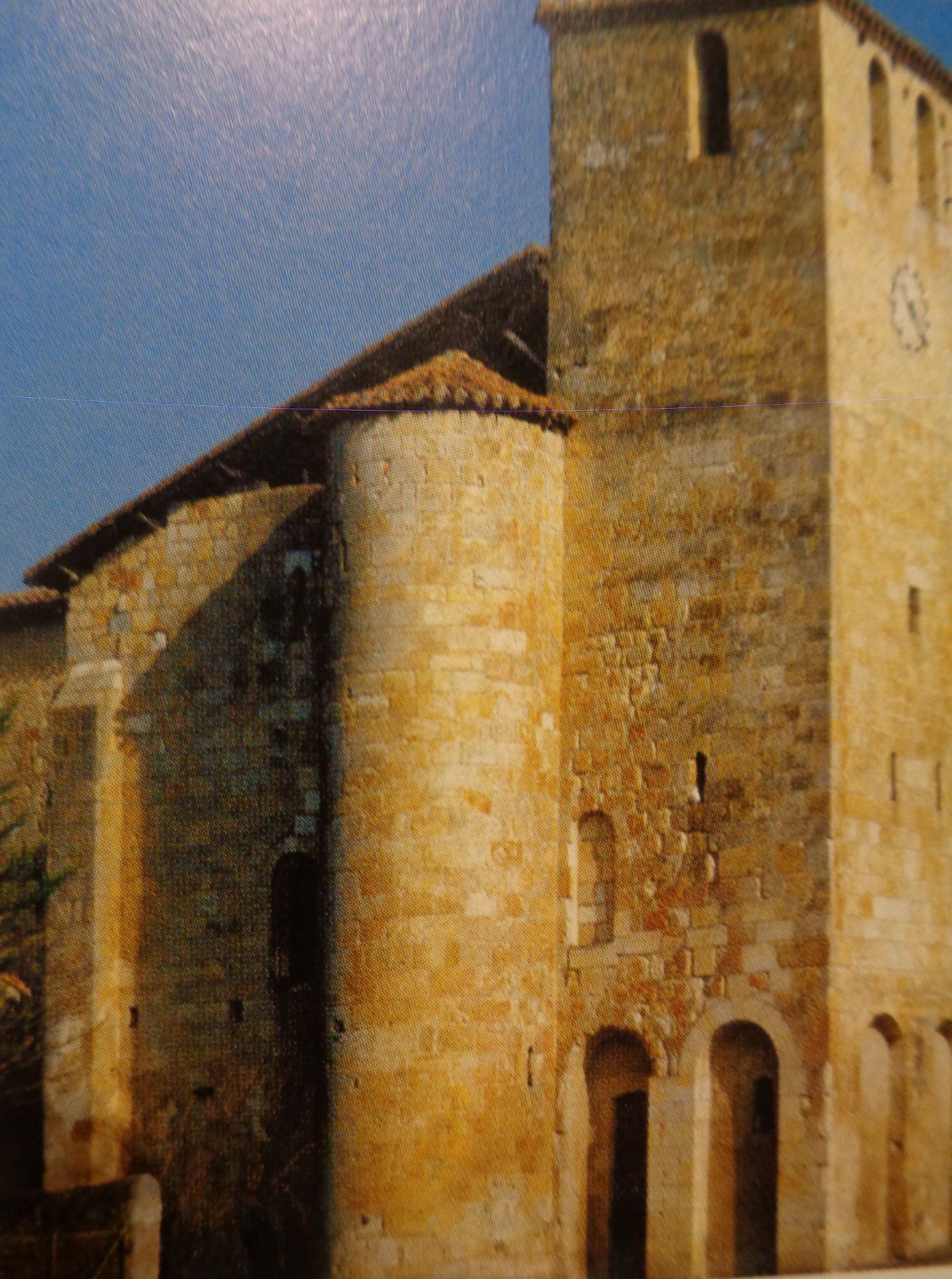
The Church Saint-Austrégésile or Saint-Pierre , ancient Clunisian priory rebuilt in the 11C on a road to Santiago de-Compostela from Puy-en-Velay. depended on the Clunisian priory of Saint-Orens d’Auch. The church is quite modest. A nave with two spans and an apse of length significantly equal to the nave. The church is a jewel of Romanesque art. A Member of the Federation of Clunisian sites, the church is located on the path leading to Santiago de Compostela. It was already a Clunisian site (3rd site in Midi-Pyrénées), This church is one of the oldest in the department with a datable part of the beginning of the 11C. Its beauty and its history, it also among the churches of the great cultural itinerary of the Council of Europe. Dedicated to Saint-Austrégésile, it contains several architectural particularities, including many capitals.
Other things to see here, me think are the Féodal Tour of the Domaine de la Salle: 12C watchtower located at a place called Lassalle 300 m from the village near the D 208 road. Old house of the castle, A Roman bridge on the old road from Puy-en-Velay. Another bridge 12C located at a place called La Bourdette 1 km west of the village near the D 931 road. A bridge which crosses the Osse river at the old water mill. There remains only one semicircular ark on the two which made up the bridge. Old Moulin à Vent located at a place called Le Moulin à Vent or at a place called Lassalle, 1 km east of the village near the D 208 road, on a hill behind the vines. Isolated mill of the circular tower type. A moulin à eau or water mill of the 12C located at a place called La Bourdette 1 km west of the village near the D931 Mill of the old priory, the base of the mill date from the construction of the bridge and the church. A lavoir and Fontaine or washhouse and fountain located at Place de la Bascule near the village.
A bit of history tell us that in the 10C, Mouchan was the seat of a doyen of the order of Cluny. During the Hundred Years War, the village underwent depredations due to the incursions of English troops. The Hundred Years War endowed the village of the watchtowers, ramparts, courtyards turrets and bridges.
The town of Mouchan on its heritage : https://www.mouchan.fr/un-site-a-decouvrir-commune-de-mouchan_fr.html
The official European Federation of Clunicians sites on Mouchan : https://candidature-patrimoine-mondial.sitesclunisiens.org/category-1-0-decouvrez-les-sites-candidats
The local Gers-Armagnac tourist office on Mouchan : https://en.gers-armagnac.com/explorer/sites-a-visiter-2/6925875_village-de-mouchan/
There you go folks, another spot in my world map or rather France’s map. Glad to have found the old pictures to give credit to Mouchan in my blog; good for the memories of always. Again, hope you enjoy the post on this is Mouchan as I.
And remember, happy travels, good health, and many cheers to all !!!
Other things to see here, me think are the Féodal Tour of the Domaine de la Salle: 12C watchtower located at a place called Lassalle 300 m from the village near the D 208 road. Old house of the castle, A Roman bridge on the old road from Puy-en-Velay. Another bridge 12C located at a place called La Bourdette 1 km west of the village near the D 931 road. A bridge which crosses the Osse river at the old water mill. There remains only one semicircular ark on the two which made up the bridge. Old Moulin à Vent located at a place called Le Moulin à Vent or at a place called Lassalle, 1 km east of the village near the D 208 road, on a hill behind the vines. Isolated mill of the circular tower type. A moulin à eau or water mill of the 12C located at a place called La Bourdette 1 km west of the village near the D931 Mill of the old priory, the base of the mill date from the construction of the bridge and the church. A lavoir and Fontaine or washhouse and fountain located at Place de la Bascule near the village.
A bit of history tell us that in the 10C, Mouchan was the seat of a doyen of the order of Cluny. During the Hundred Years War, the village underwent depredations due to the incursions of English troops. The Hundred Years War endowed the village of the watchtowers, ramparts, courtyards turrets and bridges.
The town of Mouchan on its heritage : https://www.mouchan.fr/un-site-a-decouvrir-commune-de-mouchan_fr.html
The official European Federation of Clunicians sites on Mouchan : https://candidature-patrimoine-mondial.sitesclunisiens.org/category-1-0-decouvrez-les-sites-candidats
The local Gers-Armagnac tourist office on Mouchan : https://en.gers-armagnac.com/explorer/sites-a-visiter-2/6925875_village-de-mouchan/
There you go folks, another spot in my world map or rather France’s map. Glad to have found the old pictures to give credit to Mouchan in my blog; good for the memories of always. Again, hope you enjoy the post on this is Mouchan as I.
And remember, happy travels, good health, and many cheers to all !!! 