
I will try to tell you again about the roads of my Spain, This is a daunting task, but after so many towns and sights done in my road warrior mode , the temptation is great. As you have been reading my blog , you know I love the road, the car is my second home! And while in Europe there is no difference, gone all over, Let me tell you on two picturesque quant areas of my Spain. Therefore, let me tell you the roads of my Spain, part IV !!! Hope you enjoy it as I
The first stop was Arguis belonging to the region of La Hoya de Huesca, province of Huesca, in the Autonomous Community of Aragon. It is located at the Umbría of the Sierras de Gratal and the Aguila (eagle) , 24 km from Huesca city, connected to the road network by the Autovia de Mudejar highway (A-23), which I take a lot in my France/Spain runs,
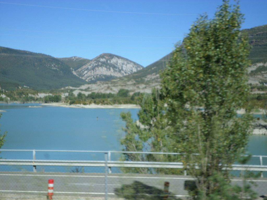
I first passed by it and was impressed by the embalse of Arguis or reservoir on the Isuela River, Off A23 (N330) Autovia de Mudéjar road, In 1929 re erection of the surface and increasing the capacity up to 2.7 hm³ , It is currently used for irrigation and recreational use such as fishing. The reservoir waters an area of 2500 ha, It is the oldest reservoir in Aragon. It was under construction for 24 years and was completed in 1704. It retained the seasonal waters of the Isuela river and was used exclusively for irrigation, mainly from the Hoya de Huesca area.
The town of Arguis is limited by the Isuela river valley and some pre -pyrenean mountains such as the Sierra de Javierre (1546 m), Sierra de Gracia (1567 m), Sierra del Águila (1609 m) and Sierra de Loarre (1470 m) and Sierra Caballera (1565 m) . The first mention of Arguis is in the cartology of San Juan de la Peña by 1070, in which Dommus Balla de Argis (the Balla de Argis house) is cited, The things to see here with more time are the Parish Church of San Miguel ,Romanesque, of the 12C, although reformed in the 16C. An altarpiece of the 15C belonging to this church can be contemplated in the Prado Museum of Madrid ! In the vicinity of the town is the ermita de Nuestra Señora de Soldevilla or hermitage of Our Lady of Soldevilla, from the 16-17C, and the ermita de la Magdalena or hermitage of the Magdalena from the 16-17C, located in Los Prados Altos de Bonés and that has a medieval necropolis of slabs
The location of the town of Arguis next to the old C-136 road that takes you to the mythical Puerto de Monrepós has made this town an icon in the motor world with various editions of rallys and climbs, such as the famous Rallye Firestone and also in the world of cycling with various stages of the Vuelta de España or Tour of Spain and the classic cycling Zaragoza-Sabiñanigo or the Aragon-Bearn. However, where this town is considered a true icon is among bikers from all over Europe that frequent the old curves of the port throughout the year, considering by the people of Arguis as the “capital of Spanish motorcycling” and comparing it even with the road to Santiago.
The town of Arguis : https://www.arguis.es/bienvenidos-a-arguis
The Hoya de Huesca municipal tourist office on natural sites : https://turismo.hoyadehuesca.es/en/la-hoya-de-huesca/natural
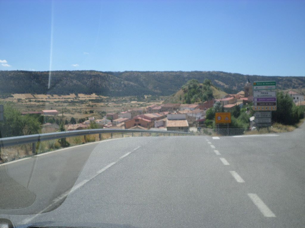
Moving right along in my beautiful Spain, I reached Calomarde in the province of Teruel, in the Autonomous Community of Aragon. It is located in the center of the Sierra de Albarracín and 50 km from Teruel. Hoz del Barranco del Río Blanco. Conditioned with stairs, catwalks and safety chains. It reaches the neighboring town of Frías de Albarracín.
While going on the road A-1704 mountain route we passed by Calomarde which is at 1584 meters elevation ! We didn’t have time to see as was not our destination but here there is the beautiful Barranco de la Hoz or canyon ravine, The Barranco de la Hoz route is one of the most spectacular routes of the Sierra de Albarracín on foot,,,, The route starts from the town of Calomarde very close to Albarracín (see post). In this route , it tells you will cross hanging bridges and catwalks of recent construction between cannons and cliffs. The route begins at the end of the town of Calomarde on the right hand as you come from Albarracín. Here you can park the car without difficulties, well we continue on,.And I am told if you want further action go visit La Cascada de Calomarde (aka Cascada Batida or Cascada del Molino Viejo) which takes you to listen to the murmurs of the Río Blanco river.
A bit of history tell us that on June 21, 1257, by privilege of King Jaime I given in Teruel, this town of Calomarde becomes part of Sesma de Frías de Albarracín ,one of the 4 sesmas or administrative divisions of the community of villages of Albarracín. It was in force from the creation at least in 1395 until the creation of the current province of Teruel in 1833. In the community of Santa María de Albarracín, which depended directly on the king, lasting this administrative regime being the only one that has remained alive after the application of the decree of dissolution of them, in 1837, having its current headquarters in Tramacastilla.
The Sierra del Albarracin on the barranco de la Hoz : https://sierraalbarracin.com/barranco-de-la-hoz
The Albarracin tourism site on Calomarde: https://albarracinturismo.com/calomarde/
There you go folks, a grandeur of freedom on the roads and to know more corners than you would like to believe, get on the road see all of Spain ! Take it from this world traveler , the best way to travel ,and in Spain you are in heaven, Do read my other posts on the roads of Spain,and you will be fine, Again, hope you enjoy this post on the roads of my Spain, part IV as I
And remember, happy travels, good health, and many cheers to all !!!
