
Well going back deep into my cd rom vault, found gladly paper pictures that should be in my blog for you and me, As said, my blog is my life’s history and so I am doing just that. I came by here many times as was my connection to the smaller islands in the Caribbean way back many years, friends still in touch! And just wonderful memories if few pictures, I am going down nostalgia lane to my roots, the Caribbean , that wonderful sea, yes ! Therefore, let me tell you my take on this is Puerto Rico !!! Hope you enjoy the post as I.
The island of Puerto Rico is an unincorporated territory of the United States with commonwealth status. Belonging to the Greater Antilles, the main island is located in the Caribbean Sea, with its northern coast washed mostly by the Atlantic Ocean . The territory consists of the island of Puerto Rico itself, as well as several smaller islands, including Vieques and Culebra, and Isla Mona. Together, they form the Commonwealth of Puerto Rico.
Christopher Columbus named the island “San Juan Bautista” in honor of Saint John the Baptist, while the port was named “Ciudad de Puerto Rico” (“City of the Rich Port”). Eventually, merchants and sailors came to refer to the entire island as Puerto Rico, while San Juan became the name used for the commercial port that would become the island’s capital. Puerto Ricans often refer to their island as “Borinquen,” derived from its indigenous Taíno name meaning “Land of the Valiant Lord.” The names “boricua” derived from “Borinquen” commonly used to identify someone from Puerto Rico. Puerto Rico has a mountainous tropical rainforest to the east, preserved by a national park called El Yunque. Many hiking trails are accessible to all, provided the right equipment is present (the forest receives an average of 6 meters of rain per year). This park is the favorite haunt of one of the island’s symbols, a small, very noisy frog called a coquí.
The Luis Muñoz Marín International Airport,the one I and everyone else arrived mostly to the island was inaugurated on May 22, 1955, under the name Isla Verde International Airport, as its footprint is located in the territory of Isla Verde, it took its current name in 1985, when then-Governor Rafael Hernández Colón decided to rename it in honor of one of his predecessors, the first to be elected, who had died five years earlier: Luis Muñoz Marín.
The City of San Juan is the capital of Puerto Rico. In 1508, Juan Ponce de León was appointed by the Spanish government as the island’s first governor. Juan Ponce de León founded the original settlement, Caparra, west of the present-day metropolitan area. The city was built on an island after 1521. The northern coast of Isla de San Juan corresponds to the district of El Condado, which extends eastward to the tourist district of Isla Verde in the town of Carolina. South of El Condado is the city of Santurce, which encompasses the beaches of Ocean Park. South of Isla de San Juan, crossing the canal, you arrive in the territory of the former town of Río Piedras, which is now annexed to San Juan, and the district of Hato Rey: San Juan’s business district. In essence all of the above is San Juan,
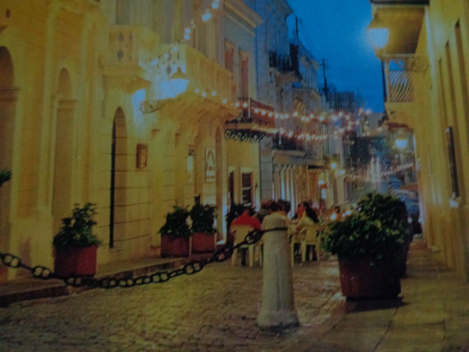
The Viejo San Juan or Old San Juan is the oldest neighborhood in San Juan, It is located on the isle of San Juan which is connected to the main island of Puerto Rico by bridges. The city is characterized by its streets of adoquins and colorful buildings that go back to the 16C and 17C, when the island was Spanish. The district is also characterized by the large number of public squares and churches, including the Catedral Metropolitana de San Juan, where it is located in the heart of the Spanish explorer Juan Ponce de León. The Catedral de San Juan Bautista, located in the heart of the walled city of Old San Juan, is the oldest cathedral in the western hemisphere, built in a neoclassical style dating from 1529. The Church San José was built from 1532 to 1735 by the Order of Dominicos as starts from its Monastery of Santo Aquino. Its current name was born by the Jesuits when it was controlled by the monastery in 1865. Dedicated to the Princess of Asturias Isabel II (Future Queen of Spain). Lined with antique lanterns, trees, statues, benches, fruit carts and street performers, this romantic stroll ends at the magnificent Raíces (roots) fountain, a stunning sculpture and water feature representing the island’s eclectic Taino, African and Spanish heritage. The Calle del Cristo (see pic) is the shopping area of Old San Juan. The cobblestone streets are lined with boutique shops, restaurants, and coffee spots. This is indeed a haven of restaurants, art galleries, and boutiques. In addition to popular stores, those walking the street can discover local crafts and artisan shops. The street has two famous chapels: the San Juan Bautista Cathedral ,and the Capilla de Cristo (only open on select days). Or swing through Parque de las Palomas or Pigeons Park to see the scores of birds waiting to be fed. A must, me think.
Ponce located in the south of Puerto Rico, is known as the “Pearl of the South”, “Stately City”, “City of Lions”, “City of the Quenepa” and “Ideal City”. It is the second largest city in Puerto Rico, located on the island’s southern coast, overlooking the Caribbean Sea. The hamlet of what would become Ponce was founded in 1692 by Juan Ponce de León y Loayza, the grandson of the Spanish conquistador Juan Ponce de León. Some of the things to see here are the Cross of the Lookout, a 30-meter-high concrete tower in the shape of a cross built on the site of the city’s historic lookout, overlooking it. The Cathedral of Our Lady of Guadalupe The Parque de Bombas, the fire station now a museum with historical pieces. The Ponce Museum of Art, founded by Luis A. Ferré in 1965, has a collection of 3,000 works, quite remarkable for a city of its size, including high-quality Italian, French, and Flemish primitive paintings.
The City Hall (see pic) fronts onto the Plaza Las Delicias, the town square of Ponce, which contains the historic Parque de Bombas and the Ponce Cathedral.The street it is on is called Calle Degetau. Construction of the building started in 1844 and was completed in 1847 it is the oldest colonial building in the city , The interesting fact is that it was a jail until the end of the 19C, Rooms currently used as offices were jail cells before, and the courtyard of the City Hall was the place where executions took place. The last public hanging on the island happened in its courtyard. It has been visited by four U.S. presidents, and three of them actually gave a speech from the City Hall’s front balcony: Theodore Roosevelt, Herbert Hoover, and Franklin Roosevelt. George H. W. Bush visited, as well.

Aguadilla was created on November 19, 1493, and it was where Christopher Columbus landed, during his second voyage, on the beach of the present-day city of Aguadilla and thus took possession of the island of Puerto Rico in the name of the Crown of Castile ! Things to see here are El Parterre ,a small park that encloses a natural water spring known as “El ojo de agua”,or of the water’s eye which flows into a stream called “El río chico”,or small river, an underground river that originates on the north coast of the island, travels more than 30 km and emerges in the center of the city of Aguadilla, in a small park built around the water source known as “El Parterre”. The ruins of the Ramey Base, a place characterized by a beautiful view of the sea towards the Caribbean Sea and the Atlantic Ocean. This being the first lighthouse in Aguadilla and although many place its construction in 1886, history dates back to the project being approved in 1887 and the remains of the Concepción fort from the early 19C were inaugurated on September 15, 1889 for the defense of the population. Also , the Casa de Piedra, or stone house ,and the 18C San Carlos Borromeo Church. Built in and around a massive banyan tree, the Casa del Árbol on the waterfront of Parque de Colón (see pic) is a tree house, an impressive 30-foot wooden structure built around a massive rubber tree. Known for its crystal-clear waters, rich cultural heritage, and family-friendly atmosphere, this beach park is the perfect place for both relaxation and adventure. The El Merendero (see pic) on Route 2 southbound lane just south of Aguadilla Mall Come here for a picturesque view of Crash Boat Beach and the coastline on Aguadilla bay.
The Rafael Hernández International Airport is the second largest airport in Puerto Rico, is located here, making Aguadilla an incredibly convenient destination if you want to avoid the hustle and bustle of San Juan. Me never use it,
The official San Juan Inter Airport: https://aeropuertosju.com/
The City of San Juan tourist office : https://explorasanjuan.com/
The City of Ponce tourist office : https://visitponce.com/cosas-que-hacer/
The City of Aguadilla site is under construction at the time of this post,
The Aguadilla Inter Airport : https://aguadilla.airport-authority.com/
The Puerto Rico tourist office on its regions : https://www.discoverpuertorico.com/regions
There you go folks, indeed a wonderful beautiful island of Puerto Rico in my Caribbean sea, Memories forever in my mind of younger wild days, and still fond of a lot. Never the youth out of me; hope you too can enjoy this heavens on earth , Again, hope you enjoy this post on this is Puerto Rico !!! as I.
And remember, happy travels, good health, and many cheers to all !!!
